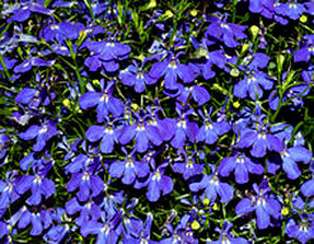
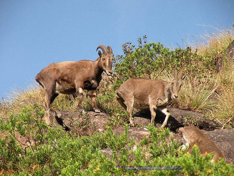
#MountainsMatter: International Mountain Day 2018 Theme Mountains matter yet they are often forgotten. Mountains play a vital role in providing essential "goods and services", especially water, to our planet. Mountain ecosystems are centers of biological diversity. These ecosystems, however, face severe threats from unsustainable land use practices (ex. overgrazing or non-conservation agriculture), illegal wood extraction, development of large-scale infrastructure (dams, roads) and unsustainable natural resource projects (fossil fuels, mining, & increased hydrocarbons). Our human well-being and livelihoods cannot be sustained without healthy ecosystems. Mountains also provide vulnerability in the "face of climate change", People living among mountains face subsistence challenges brought about by elevation, rough topography and even severe climate. https://adaptation-undp.org/projects/mountain-eba 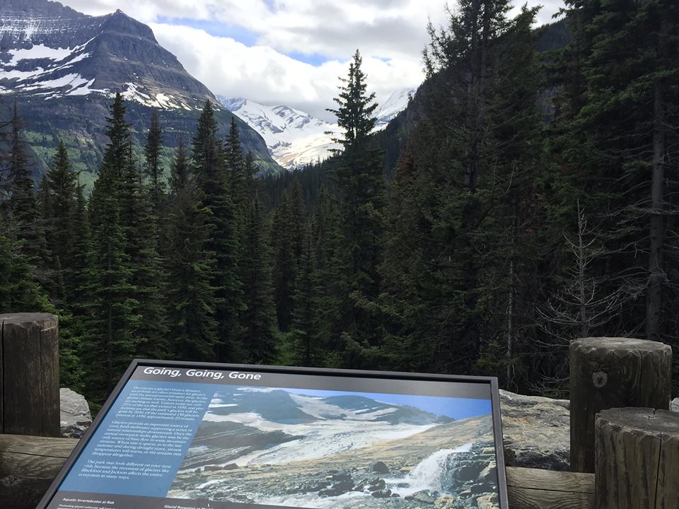 "Going, Going, Gone" - Glacier National Park Photo by Marta Farrell "Glacier National Park continues to lose its glaciers as global temperatures rise. Initially, this park had about 150 glaciers when it was founded in 1910. "Today, only 26 still meet the 25-acre threshold to be called a glacier." Credit: Jinrui Qu/CC-BY-SA-2.0 #MountainsMatter for Water: Think of mountains as the world’s 'water towers’, providing between 60-80% of all freshwater resources for our planet. Reliable resources indicate that glaciers in mountain ranges around the world are retreating and disappearing due to climate change. As many as 600 glaciers have disappeared completely over past decades, affecting water supplies relied on by billions living downstream. Five Thousand Miles of Wild; "It's More than a River, it's our way of life." https://www.5000miles.org/ #5000 Miles of Wild In 2018, we celebrated the 50th Anniversary of the Wild & Scenic Rivers Act. We continue this celebration in 2019 as tribute to the 50th Anniversary of the Little Miami River being named a State and National Scenic River. http://watercraft.ohiodnr.gov/Portals/watercraft/pdfs/maps/srLittleMiami.pdf #MountainsMatters for Disaster Risk Reduction as climatic variations are triggering disasters. Avalanches, mudflows and landslides are tumbling downstream, stripping bare forests, flooding communities and populations. #MountainsMatter for Tourism: Mountain destinations attract roughly 15-20% of global tourism; these are areas of important heritage, knowledge and cultural diversity, . Such tourism has potential to affect or foster economic development especially in remote and isolated regions. Unfortunately, many mountain communities are not benefiting and still live in poverty. #MountainsMatter for Food: Mountain regions are important centers of agricultural biodiversity; they are "home to many of the foods that come to our table"...rice, potatoes, quinoa, tomatoes and barley. Sadly, such regions are home to some of the hungriest peoples in the world given a high vulnerability to food shortages and malnutrition; climate change is directly affecting mountain agriculture. #MountainsMatter for Youth: Despite magnificent landscapes, rural life in mountainous regions can be "tough", particularly for the youth; abandoning their villages in search of employment elsewhere has lead to an absence of young people. This directly increases labor shortages. Consequently, migration from mountain regions has lead to an increase in abandoned agricultural, land degradation to even forest fires. Consequently, many cultural values and ancient traditions are lost. #MountainsMatter for Indigenous Peoples: Many mountainous areas host ancient indigenous communities that often posses and maintain unique knowledge, languages and traditions. Mountain peoples have developed unique land-use systems; they posses a wealth of knowledge and strategies that have accumulated over generations, including how to adapt to climate variability. #MountainsMatter for Biodiversity: Half of the world’s biodiversity hotspots are concentrated in mountains where approximately 25% of terrestrial biological diversity is supported. Mountains are home to many rare wildlife such as gorillas, snow leopards, the majestic tahr and strikingly, beautiful plants such as orchids and lobelias. International Mountain Day is an occasion to create a large social movement that can bring mountain issues "at large". Take a "step-up" and raise attention to mountains. #MountainsMatter
 "Human wellbeing and livelihoods cannot be sustained without healthy ecosystems." UNITED NATIONS DEVELOPMENT PROGRAMME https://adaptation-undp.org/projects/mountain-EbA Some of the many "Public Lands to Explore in Winter" See: https://www.doi.gov/blog/20-public-lands-explore-this-winter  Gallery Photos by Marta Farrell Seasons in the Smokies: https://www.nps.gov/media/photo/gallery.htm?id=28D901AE-1DD8-B71C-078D04CCD4FBAFBC Glacier National Park in Montana 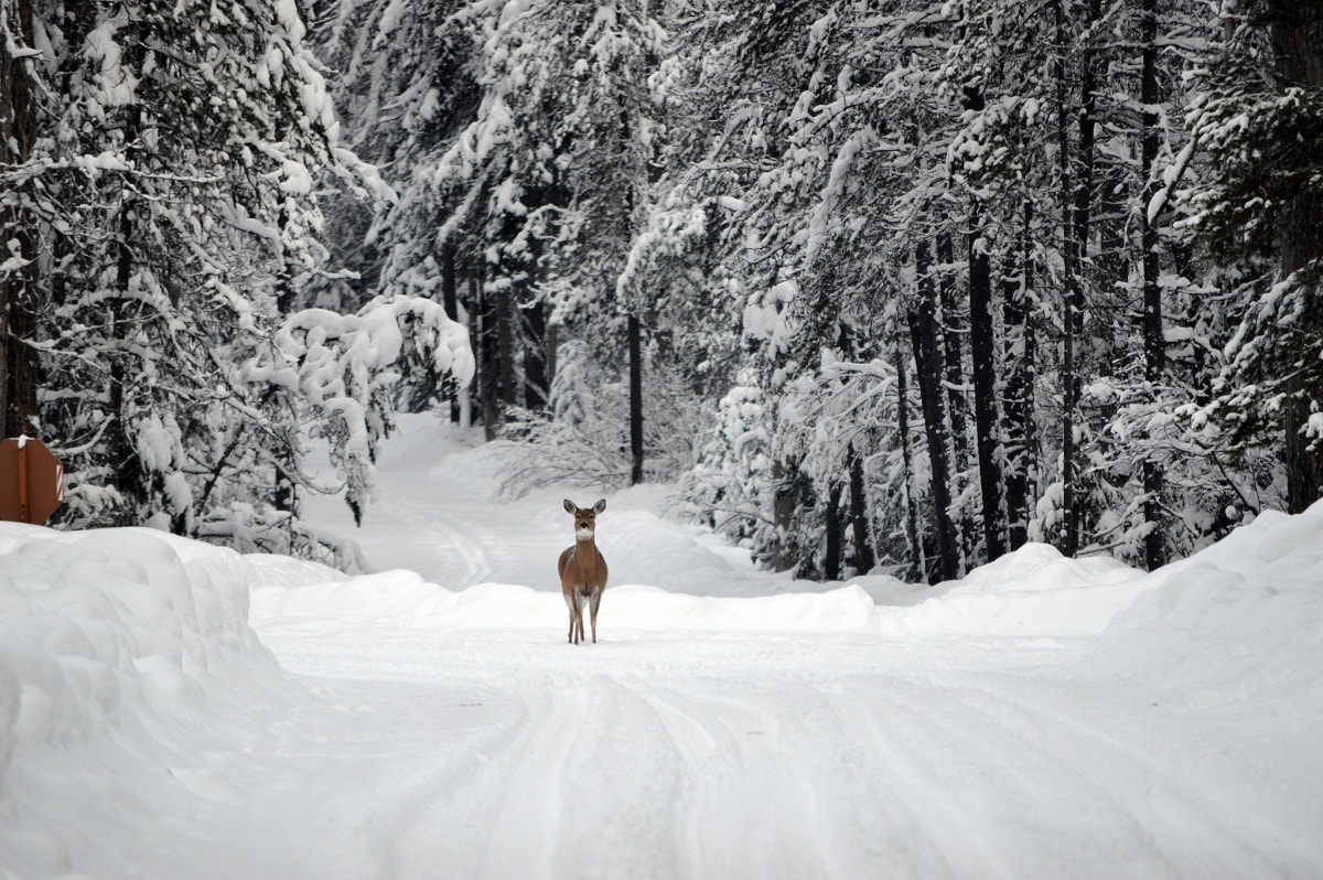 Photo above by Bill Hayden, National Park Service If you love snow, Mother Nature blankets the landscape in white at Glacier National Park. As the snow accumulates in Glacier, snowshoeing and skiing are among some of the favorite recreational activities in the park along with watching the wildlife come out to play. Glacier National Park Gallery Photos by Marta Farrell Yellowstone National Park 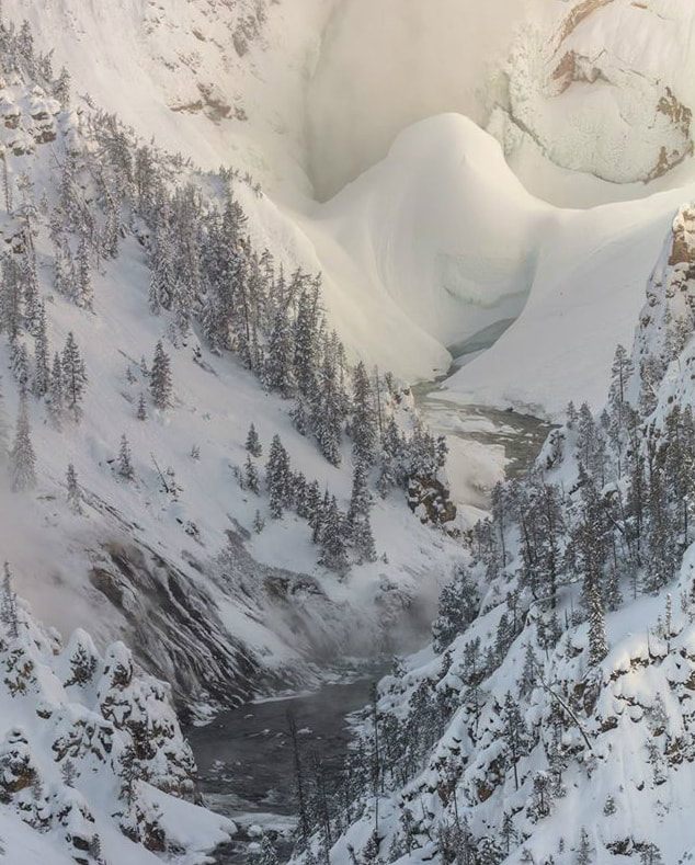 Photo above by the National Park Service Winter at Yellowstone National Park indicates fewer crowds, frigid temperatures, and steaming geyser basins, hibernation or even migration. Skis, snowshoes and snowmobiles are often the primary modes of transportation as roads close, rivers and lakes freeze and snowstorms transform the park. One of the most amazing winter sights at the park is the ice dam at Lower Falls. Often growing over 100 feet tall, it’s known as an "astounding natural spectacle". Yelllowstone N.P. Gallery Photos by M.J. Farrell and Marta Farrell Starry Night: The Milky Way glows in the sky over a geologic formation known as Monument Rocks in Gove County, Kansas. The Milky Way is best viewed on moonless summer nights, far from the light pollution created by cities and towns. Astronomers believe our galaxy contains about 200 billion stars. 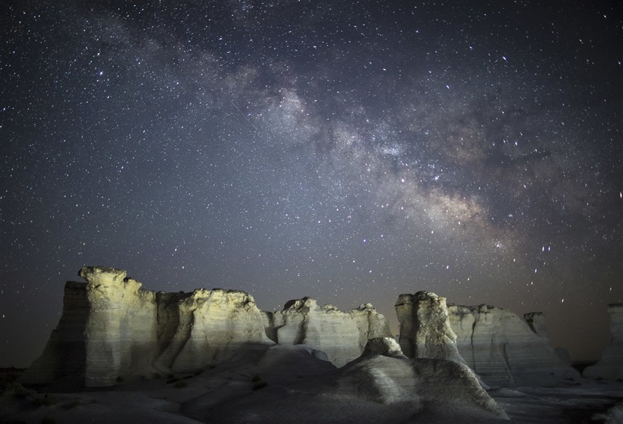 — Travis Heying / The Wichita Eagle via AP Year in Space Pictures - 2018: https://www.nbcnews.com/mach/science/year-space-pictures-2018-ncsl950631?utm_source=Sailthru&utm_medium=email&utm_campaign=Morning%20Rundown%20Dec%2031&utm_term=Morning%20Rundown Geologists create a basic unit called a formation to classify and map layers of rock. Thus, a formation is a rock unit that is distinctive enough in appearance that a geologic mapper can tell it apart from the surrounding rock layers; also, the rock formation must be thick enough and extensive enough to plot on a map. "Formations are given names that include the geographic name of a permanent feature near the location where the rocks are well exposed. If the formation consists of a single or dominant rock type, such as shale or sandstone, then the rock type is included in the name." - By Christine Wilkerson, Utah Geological Survey "What is A Formation?" Rocky Mountain National Park in Colorado 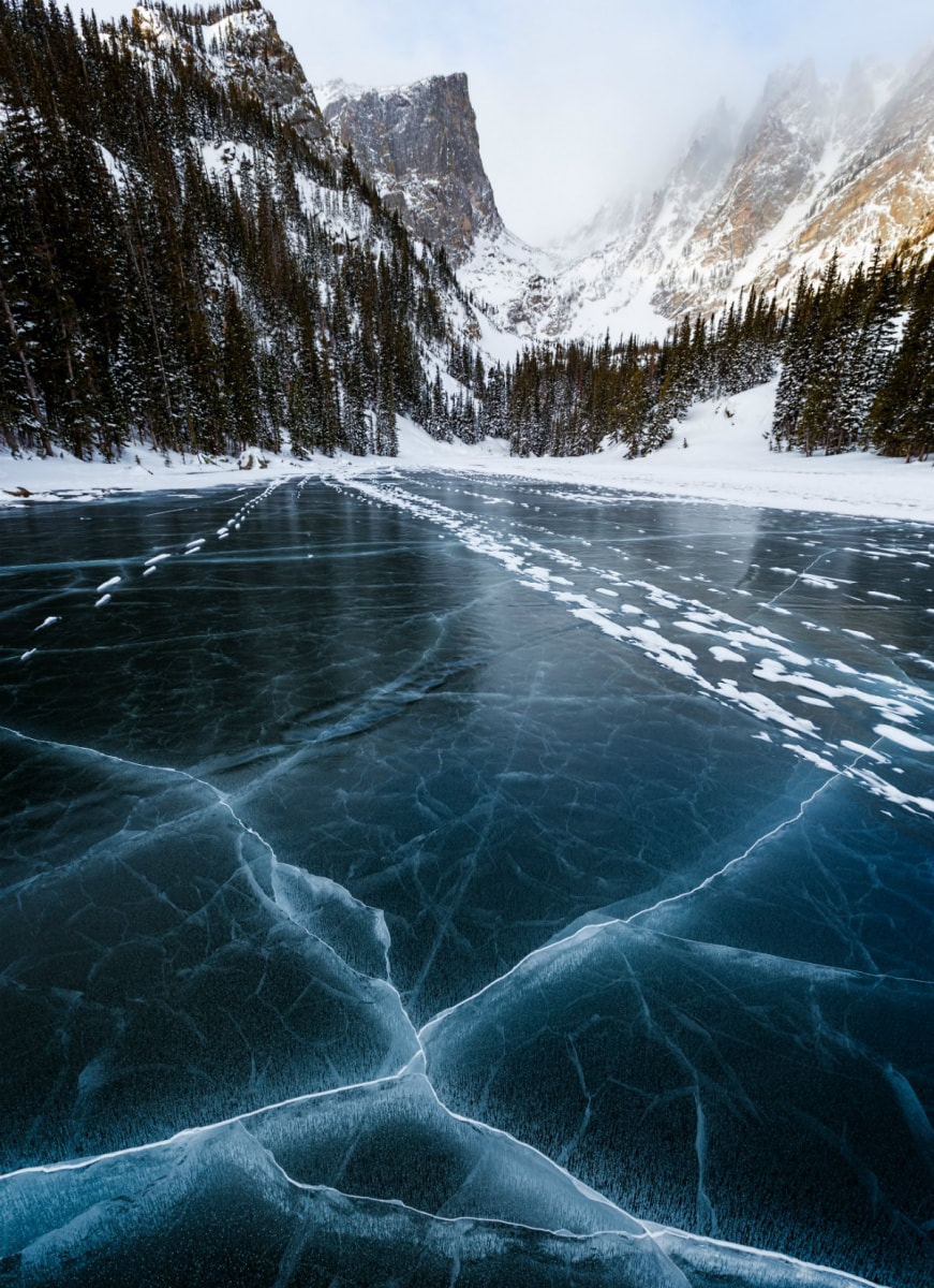 Photo above by Carl Finocchiaro "Cracks in Dream Lake create a gorgeous but perilous, natural tapestry at Rocky Mountain National Park." Always test ice first before walking on it; never take chances when walking on ice. In the winter, enjoy site-seeing, watching wildlife, sledding, snowshoeing, cross-country skiing, or hiking while exploring Rocky Mountain’s spectacular mountainous environments. Iditarod National Historic Trail in Alaska  Photo above by Kevin Keeler, Bureau of Land Management. Encompassing a 1,500-mile system of winter trails, the Iditarod National Historic Trail initially connected ancient Alaska Native villages and opened up Alaska for the gold rush; it continues to play a vital role for travel and recreation. This trail is maintained by the Bureau of Land Management and it is often identified with the famous annual Iditarod - sled dog race. This annual race starts each year in March. There are upmost challenges the racer and the 21-dog team face given harsh conditions across rugged but beautiful Alaskan terrain. Meanwhile, dog mushing is the traditional Alaska winter transportation. Dogsledding, or the practice of a musher guiding a team of dogs pulling a sled over ice and snow, may serve multiple purposes. "Whether it’s a casual run along public recreational trails, racing against competitors, or hauling supplies, public lands have much to offer." -https://www.blm.gov/programs/recreation/recreation-activities/alaska
0 Comments
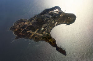
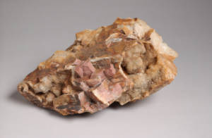
Glaciers to Great Lake: Ohio would not be what it is today without the impact of glaciers during the Ice Age. Glaciers left behind more than just till deposits in Ohio, glaciers also helped make Lake Erie. Check out this video and learn more about Ohio's Ice Age: http://www.pbs.org/video/wptd-our-ohio-glaciers-great-lake/ (Running time: Approx. 2 minutes) - WCET Cincinnati, Our Ohio series Glacial Grooves State Park, Kelley's Island 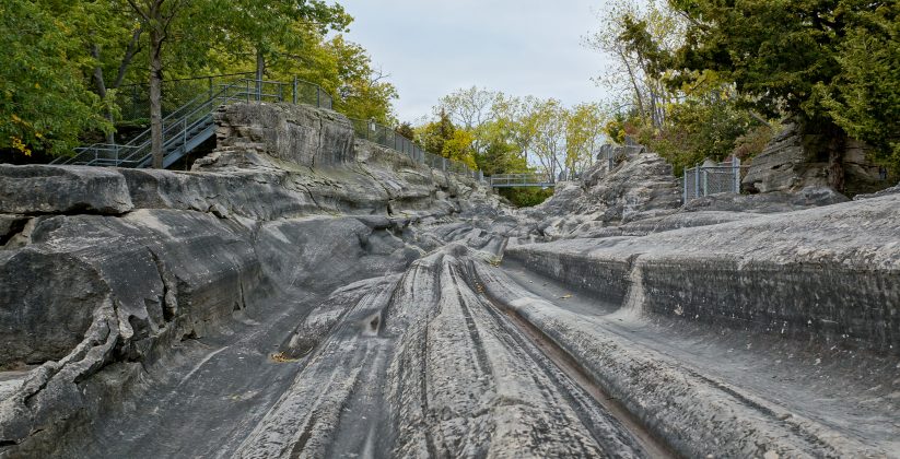 These glacial grooves were carved out during the Pleistocene Epoch (the last Ice Age). 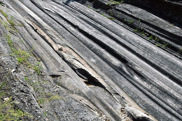 Stories in the Stones Underneath the soils of Ohio lies a vast record of history embedded in rocks and minerals: http://geosurvey.ohiodnr.gov/news-events/multimedia-library 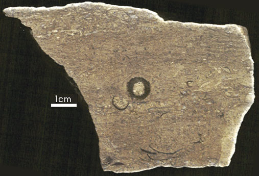 Etched section of hand sample of Columbus Limestone from quarry on Kelley's Island. The circular feature is a crinoid columnal. 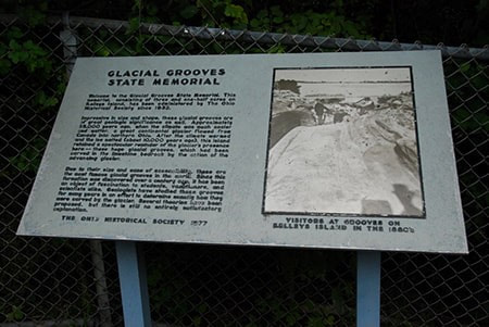 Glacial Map of Ohio: geosurvey.ohiodnr.gov/portals/geosurvey/PDFs/Glacial/glacial.pdf Flint is Ohio's official gemstone. Flint Ridge Flint is renowned for its color and beauty. In pre-historic times, flint was used by American Indians for tools, including knives and spear points. The flint polished stone is valued in jewelry making today. Licking and Western Muskingum Counties are known for having the most famous deposit of flint in Ohio; this area is better known as Flint Ridge. Flint Ridge Flint became Ohio's official gemstone in 1965.
Ohio's Geological Walk Through Time Located at the Natural Resources Park on the Ohio State Fairgrounds, this exhibit offers a unique learning experience for anyone interested in Ohio's natural history, including fossils, rocks & minerals, and more. www2.ohiodnr.gov/ohio-state-fair/geological-walk
Geoscience News and Information - more on rocks, minerals...geology.com/ Learning about rocks and minerals gives a deeper appreciation of the story behind the scenery in our National Parks. - National Park Service Yellowstone National park Rocks and minerals are all around us and used in our everyday lives. They also help us to develop new technologies. Rocks and minerals are used in building material, cars, roads, appliances and even in cosmetics. Humans need to consume minerals on a daily basis in order to maintain a healthy lifestyle that includes strengthening the body. Abiotic features, like rocks and minerals, play a valuable role in our natural systems such as providing soil nutrients in Redwood where the tallest trees in the world grow or provide habitat like the cliffs at Grand Canyon National Park where endangered condors nest. We can learn more about Earth's materials, structure, and systems through studying rocks and minerals. "Natural objects, such as rocks and minerals, contribute to the beauty and wonderment of the National Parks and should be left, as they were found, so that others can experience a sense of discovery." - https://www.nps.gov/subjects/geology/rocks-and-minerals.htm Glacier National Park, MTWaterton - Glacier International Peace Park World Heritage Site Glacier's pristine forests, alpine meadows, rugged mountains, spectacular lakes and wildlife are truly spectacular sites. dEATH vALLEY nATIONAL pARK, ca, nv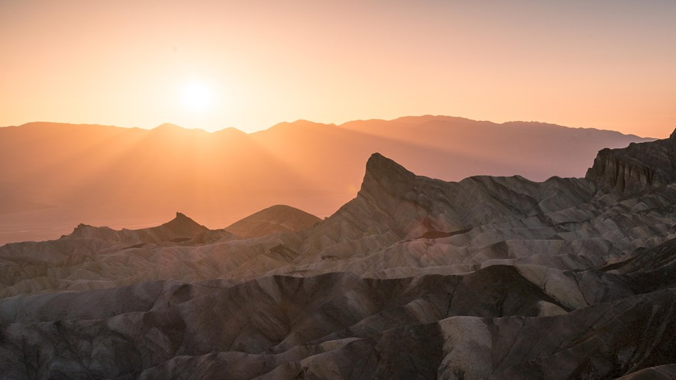 Hottest, Driest, and Lowest National Park: Steady drought and record summer heat make Death Valley a land of extremes in this "below-sea-level basin". Each "extreme has a striking contrast": towering peaks are frosted with winter snow, rare rainstorms bring vast fields of wildflowers, lush oases harbor tiny fish along with refuge for wildlife and humans. "Despite its morbid name, a great diversity of life survives in Death Valley."
Educators and Volunteers - "Natural Parks are America's Largest Classrooms!" https://www.nps.gov/teachers/index.htm Science in your National Parks: https://www.nps.gov/nature/index.htm
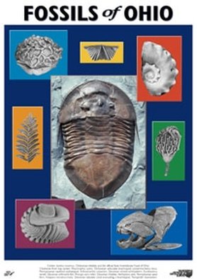
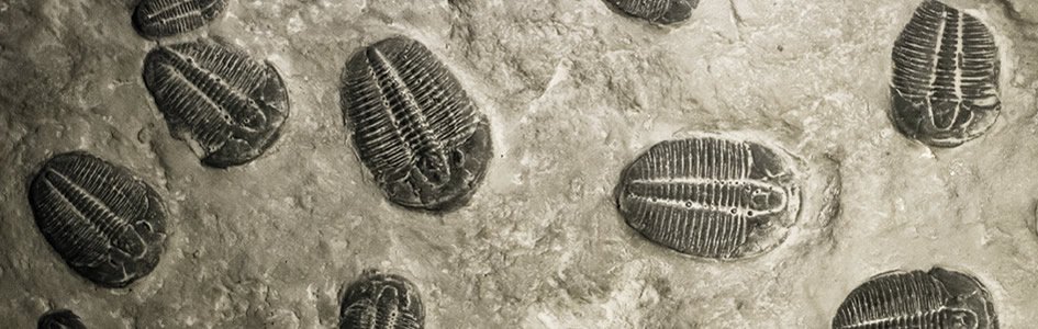 What is a Fossil? A fossil is the naturally preserved remains or traces of organisms that lived in the geologic past. There are two main types of fossils; body and trace. Body fossils include the remains of organisms that were once living and trace fossils are the signs that organisms were present (i.e. footprints, tracks, trails, and burrows). - imnh.isu.edu/digitalatlas/geo/basics/fossil.htm "Any direct evidence of ancient life, including the remains or traces of plants or animals. The term "fossil" does not include any life forms that have been buried since the beginning of historic time." - www.ohiohistorycentral.org/w/Fossil 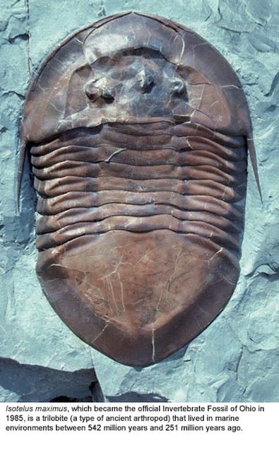  Ohio's Geologic Timeline: "Since the oldest sedimentary rocks in Ohio were deposited first, they lie below the youngest rocks. Therefore, if a layer of sedimentary rock lies on top of another layer of such rock, the top layer is younger than that beneath it. This holds true in Ohio EXCEPT in cases where a force has disturbed the layers after they were deposited." - www.ohiohistorycentral.org/w/Ohio%27s_Geologic_Timeline  Fossils of Ohio – A great tool to help identify fossils found throughout Ohio, designed for use by beginners to professionals geosurvey.ohiodnr.gov/major-topics/fossils-in-ohio Most land in Ohio is private property. Always obtain permission before collecting fossils. Most public lands (local, state, or federal) do not permit fossil collecting, except in designated areas. Fossils and Fossil Hunting in Ohio Once covered by vast tropical seas and later by giant glaciers, Ohio's landscape features an abundance of fossils. The glaciated portions of Ohio are home to Ice Age fossils, including plants and ancient mammals. But southwestern and northwestern Ohio boast a wider variety of much older marine fossils, including the official state fossil Isotelus maximus. In fact, the greater Cincinnati region lures paleontologists, fossil collectors, and rock hounds from all across the country and beyond who seek and have discovered some of the best fossil specimens in the world. - geosurvey.ohiodnr.gov/major-topics/fossils-in-ohio Public Sites in Southwest Ohio - Visitors should contact park management staff prior to collecting to obtain any permits and/or rules that may apply. Caesar Creek State Park (Clinton/Warren Counties) – Geology: Ordovician; fossils ranging from 450 to 500 million years old found in limestone forming the crest of the Cincinnati Arch. Collecting rules apply and a permit must be obtained at the U.S. Army Corps of Engineer's Visitor Center, which also features a display of fossils found at the park. For more information about fossil hunting at Caesar Creek, call (513) 897-1050. Cowan Lake State Park (Clinton County) – Geology: Ordovician; fossils ranging from 450 to 500 million years old found in limestone forming the eastern edge of the Cincinnati Arch. Special permission to collect fossils must be obtained from Ohio State Parks. For more information, call (513) 897-3055. East Fork State Park (Clermont County) – Geology: Ordovician; fossils ranging from 450 to 500 million years old in interbedded shale and limestone. Collecting rules apply. A permit must be obtained at the U.S. Army Corps of Engineers Visitor Center. For more information, call (513) 734-4323. Hueston Woods State Park (Preble/Butler Counties) – Geology: Ordovician; fossils ranging from 450 to 500 million years old in limestone and dolomite forming the western edge of the Cincinnati Arch. For more information, call (513) 523-6347. Oakes Quarry Park (Greene County) – Geology: Silurian; fossils around 425 million years old. Located in city of Fairborn, northeast of Dayton. For more information, call (937) 754-3090 or see ( Ohio Geology, 2008 No. 2[800 KB PDF]. Stonelick State Park (Clermont County) – Geology: Ordovician; fossils ranging from 450 to 500 million years old in interbedded shale and limestone. For more information, call (513) 734-4323. Trammel Fossil Park (Hamilton County) – Geology: Ordovician; fossils ranging from 450 to 500 million years old in interbedded shale and limestone. For more information, call (513) 563-2985.  drydredgers.org/caesar_creek.htm www.fossilguy.com/sites/caesar-creek/caesar-creek-fossils.htm#trilobite 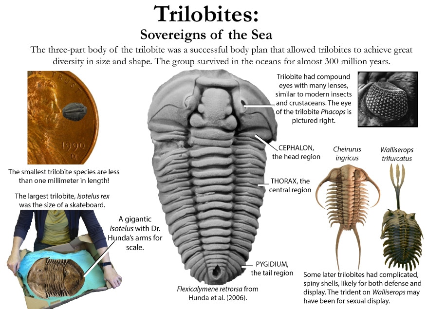 What are the oldest fossils? The earliest evidence of life on earth is of marine animals, during the Precambrian era. But there is only sparse evidence of life before the Cambrian era. The oldest known Precambrian rocks, found in Africa and Australia, are believed to be more than three billion years old. The fossils found among them are of the oldest known organisms on earth. Usually, fossils found in these old rocks are microfossils, such as elongated bacteria, Eobacterium and other water environment fossils. Bacteria represents the first stage of recognizable organized life and scientists have found well defined remains of algae and bacteria from nearly two billion years ago. Where are most fossils found? The most common fossils are found in sedimentary rock. Sedimentary layers act as evidence of the changing climate or movement of the continents during the passage of time. The Law of Superposition or Steno's law states that in a pile of undisturbed sedimentary rock, the oldest bed will lie at the bottom and the youngest on top. Layers of strata in different locations may have the same composition but carry fossils of a different time period, therefore a technique of zoning or an index fossil is used. Index fossils are specific animals or plants that had a broad geographical distribution but existed for relatively short periods of time. These fossils allow geologists to establish a parallel between layers of sediment. Some excellent guide fossils are ammonites; each species lived for relatively short periods of time but had such a broad geographical distribution. They can be found today in stratigraphic rock layers often separated by great distances. The appearance of the same ammonite in different layers in different localities gives evidence that those layers were deposited at the same time. Each time period is marked by an abundant radiation of many new life forms or the mass extinction of past life forms. - www.ucmp.berkeley.edu/paleo/fossils/index.html  "Many world-famous paleontologists—geologists who study fossils—began their careers as youngsters collecting fossils in their native Ohio. Fossils from Ohio are important constituents of museum collections throughout the United States and Europe." - Fossils Collecting in Ohio ODNR GeoFacts - geosurvey.ohiodnr.gov/portals/geosurvey/PDFs/GeoFacts/geof17.pdf
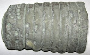
As previously conveyed, "Fossils" are the remains of an ancient organism or the traces of activity of such an organism. There are two types of fossils: body fossils and trace fossils. Body fossils include preserved remains of an organism (i.e. freezing, drying, petrification, permineralization, bacteria and algea). Trace fossils are the indirect signs of life that give evidence of the organism's presence (i.e. footprints, burrows, trails & other evidence of life processes). www.ucmp.berkeley.edu/paleo/fossils/index.html What are cast and mold fossils? Casts and molds are types of fossilization where the physical characteristics of organisms are impressed onto rocks, especially coarse porous rocks such as sandstones. Typically, the hard parts of an organism ( shells of mollusks, skeletal structures of coelenterates, bones and teeth of vertebrate, chitinous exoskeleton of arthropods, trunks of trees, and many sphenophyte ) leave the best impressions. These hard structures are usually composed of calcium carbonate, calcium phosphate, silica, or chitin, and do not decay as easily. The rigidity of the hard body parts also allows the sediment to form around the organism. Soft body parts decay too fast for impressions to form and are not rigid enough for a mold to set around. Fossilization Process: The fossilization process begins when the whole organism or hard body part is trapped in sediments. Because most of these body parts are typically composed of substances which are soluble in carbonated water, this entrapment usually occurs in coarse and porous rock such as sandstones. The porous nature of the rock enables the carbonated ground water to permeate and dissolve the original tissue leaving a detailed mold of the organism. Two types of molds result from this process: external and internal. An external mold is created with the dissolution of the organic which then leaves an empty cavity imprinted with the external details of the organism. An internal mold may form with hollow structures. The "shell" of the organism is filled with various inorganic materials such as sediment or crystals. When the shell dissolves, it leaves an impression of the interior surface of the shells (e.g., muscle scars) on the material. A cast of the organism can then be made using the two types of molds. Natural casts are formed when minerals are deposited within the mold. Casts can also be synthetically created when the molds are filled or covered with synthetic material, such as latex or plaster of paris, to generate a replica of the organism. In this manner, cast and mold fossilization enables us to "recreate" the structure of the organism. However in the creation of the cast, some details of the skeletal structures are lost. www.ucmp.berkeley.edu/paleo/fossils/casmol.html 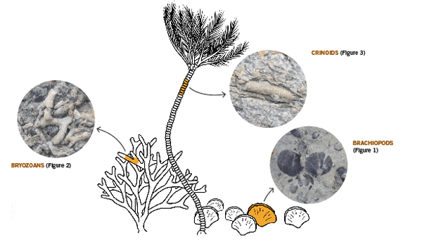 BRACHIOPODS (Figure 1) “Lampshells” are sea animals with hard shells that were hinged at the rear. The Flood ripped the shells apart, burying piles of them in slabs of limestone. BRYOZOANS (Figure 2) “Lace corals” were colonies of sea animals that lived together in connected modules, called zooids. The Flood tore apart these colonies, leaving only piles of broken “stems” and “branches.” CRINOIDS (Figure 3) “Sea lilies” were animals that attached to the seafloor on long columns. The Flood tore apart their bodies, leaving only piles of broken pieces of the stems, called “columnals.” https://answersingenesis.org/fossils/fossil-record/cincinnati-built-on-a-fossil-graveyard/ Types of Fossils: Fossils undergo a variety of different fossilization processes, depending on the characteristics of the particular organism. There are various levels of fossil preservation, each containing its own clues pertaining to the organism. Fossilization at the cellular level varies in all organic compounds since not all cellular types are equally resistant to decay and decomposition. The same hold at the tissue level, where some tissue types are more susceptible to fossilization. The other two kinds include the organ level and organism level which provide information in the field of morphology and biology of the ancient organism. Although there are an endless number of categories, we will focus on the broader mode of classification. Permineralization: is the occurrence of decay of organic substances and filling of mineral material into every cavity of the organism, still retaining most information about the fossil.
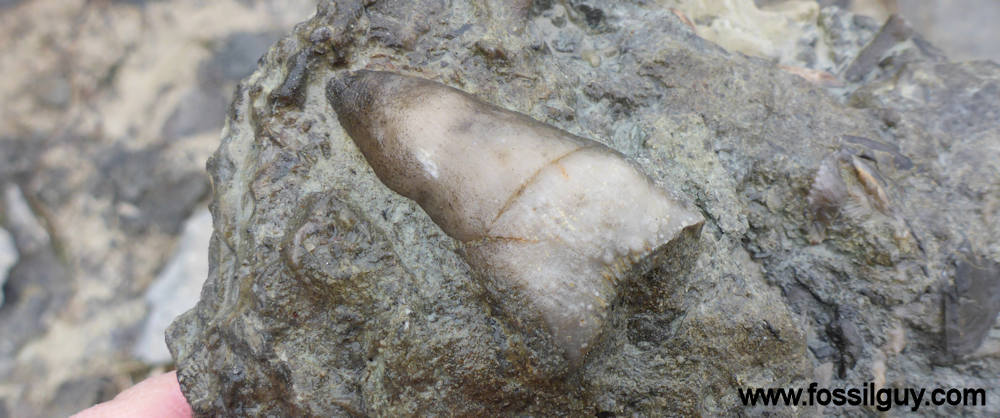
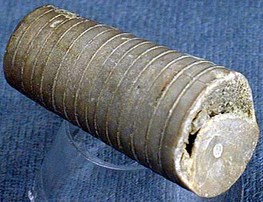
Additional Links: Visit one of these websites to learn and research more about Ohio's Fossils. This can assist you in identifying your own fossils. Schedule a trip to fossil hunt or tour a museum to explore fascinating exhibits and examine rocks, minerals, and fossils from Ohio and around the world....plus much more. DRY DREDGERS – A CINCINNATI-BASED ASSOCIATION OF AMATEUR GEOLOGISTS AND FOSSIL COLLECTORS CLEVELAND MUSEUM OF NATURAL HISTORY MUSEUM OF NATURAL HISTORY & SCIENCE – AT CINCINNATI MUSEUM CENTER ORTON GEOLOGICAL MUSEUM – AT THE OHIO STATE UNIVERSITY SCHOOL OF EARTH SCIENCES Ohio's Geological Walk Through Time Located at the Natural Resources Park on the Ohio State Fairgrounds, this exhibit offers a unique learning experience for anyone interested in Ohio's natural history, including fossils, rocks & minerals, and more. www2.ohiodnr.gov/ohio-state-fair/geological-walk University of Cincinnati Department of Geology Covered in Shells (Greater Cincinnati): thenaturalhistorian.com/2011/09/14/covered-in-shells-how-many-fossils-are-there/ Smithsonian Natural Museum of Natural History - The Department of Paleobiology: http://paleobiology.si.edu/index.html Virtual Museum of Geology: www.virtualmuseumofgeology.com/ Other State Geological Survey Web Sites (via AASG) Geology Departments at Ohio Colleges and Universities Ohio Rock and Mineral Clubs—Listing from the Midwest Federation of Mineralogical & Geological Societies. Geology and Science Education Web Sites Science Education Associations AGI Classroom Activities for K-12 Students How are fossils found? There are certain techniques that paleontologists might exercise to find fossils, but it mostly has to do with chance and luck. However, all paleontologists need a place to start. Paleontologists must have an extensive knowledge of the stromatolites, the different eras, and which environment was most suitable for certain organisms. With this information, a collector can eliminate certain localities in his or her search. For example, if a collector was interested in finding fossils of animals of ancient rocky shores, he or she would eliminate formations and beds in which remains are likely to be rare and poor. Paleontologists can also follow leads that other paleontologists or collectors have left behind in published reports. These clues help narrow the focus of the search. For example, marsh plants are most abundant in shales and sandstones between beds of coal, and coals are found in limy shales and massive limestones, many of which are the remains of ancient reefs. Using these techniques, the process of elimination, and perhaps some luck, paleontologists have retrieved many different fossils and animal remains from a variety of geological areas. Conditions that lead to fossilization: There are many conditions that contribute to the formation of fossils. The most common include the possession of hard parts, such as a skeleton or shell, and a rapid burial after death. Besides being tough and hard, the organism must come to rest in a place where it can be buried before it decays or disintegrates. If the organism is not buried deeply and quickly, aerobic bacteria will reduce it to rubble. Water, given enough time, can also dissolve it. For this reason, fossils of some organisms are more rare than others. The skeletons that contain a high percentage of mineral matter are most readily preserved. The soft tissue that is not intimately connected with skeletal parts is least likely to be preserved. Other conditions that lead to fossilization include resting an environment that was biologically inert, areas that are receiving a large, steady supply of sediment (deltas of major rivers), and parts of the earth below sea level compared to those above the sea level. The ideal place to become a fossil is at the bottom of a quiet sea or lake where the prospective fossil is safe from damage and can be covered rapidly with sediment. Clay offers excellent conditions where the sediment protects the tissues and helps to exclude predators and solvent water. - www.ucmp.berkeley.edu/paleo/fossils/index.html Trammel Fossil Park - "A Rocking Good Time" http://www.familyfriendlycincinnati.com/2011/05/24/trammel-fossil-park-a-rocking-good-time/ 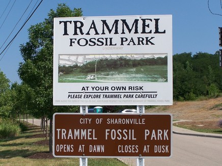 "The Corryville Formation is named after the Corryville neighborhood of Cincinnati, near the University of Cincinnati. Fine particles settling out of the seas formed the shale layers that you see in the Corryville. These fine particles resulted from erosion and runoff from the uplifted Appalachian Mountains, east of this region. From the Corryville shale, some of the most rate fossils have been found. In many other local areas, the soft shale has eroded away. Trammel Park is unique in that the Corryville Formation is exposed and undisturbed."- http://local.aaca.org/siraaca/Fossils.htm 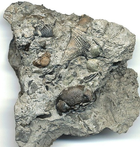 What do fossils tell us? "Different fossils, depending upon how they were preserved, tell us different things. For example, fossils that are preserved in amber give us an extraordinary amount of information about the anatomy of that organism; since the organisms that are preserved in amber, mostly insects, are usually preserved intact without any disintegration of organs, muscles, and coloring. Even bones may tell a great deal about the soft anatomy. For instance, the area where the muscle attaches to the bone leaves marks that indicate size, shape, and functions of these varied organs. Also, the cavities and the the channels in skulls give us an idea of their intelligence, behavior, and their principle features. Certain parts of certain fossils can also tell us about growth, injury, disease, form, function, activities, and instincts. Fossils also record the successive evolutionary diversification of living things, the successive colonization of habitats, and the development of increasingly complex organic communities. Fossils can tell a great deal about their surroundings and the conditions under which they lived. Finally, study of fossils contributes greatly to the study of evolution. They are the only direct record of what has occurred in sequences of reproducing populations and in the course of the time on an evolutionary scale." www.ucmp.berkeley.edu/paleo/fossils/index.html 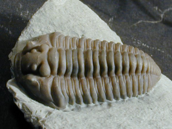 Trilobite Fossils: Trilobites are a group of extinct arthropods (similar to crustaceans) with a hard shell. They are common in Ordovician rocks in the Cincinnati Arch. Unfortunately, almost all are fragments. Occasionally whole ones are found. The whole trilobites are usually found enrolled. There are over a dozen trilobites found in this strata. The most common two are Flexicalymene and Isotelus. www.fossilguy.com/sites/caesar-creek/caesar-creek-fossils.htm#trilobite 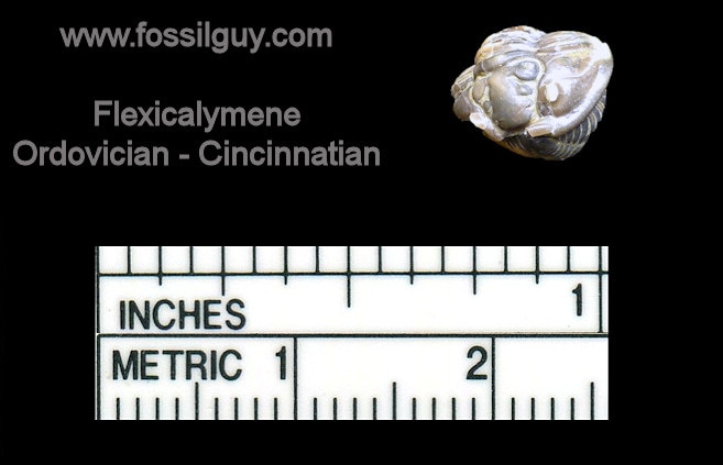 "This is a typical flexicalymene retrorsa minuens trilobite fossil that can be found at Caesar Creek. Flexicalymene trilobites in the Caesar Creek area are reduced in size and most often found enrolled. They are usually the size of a fingernail or smaller. When searching for them, they superficially look like tiny brachiopods, so take your time, look closely, and you may find one!" 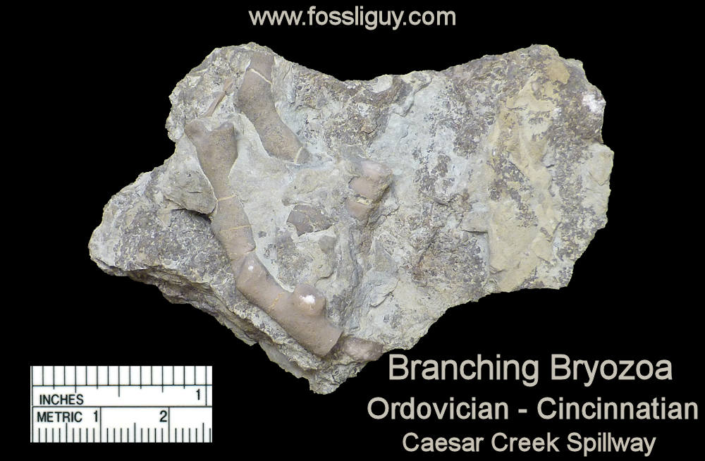 Bryozoans are tiny colonial organisms, often mistaken for corals. The individual bryozoan is usually less than 1 mm in size. Bryozoan colonies can be branching, twiglike, fan-like, or encrusting. The entire colony is referred to as a zoarium. Some bryozoan colonies are smooth and others have monticules or bumps covering them. Each small opening or aperture was the home for an individual bryozoan or zooecium. The small animal seals the hole with a “door” or vestibule. They are difficult to identify without microscopic study. Sometimes the pattern of the apertures, size, or shape is characteristic and can be used for generic identification. 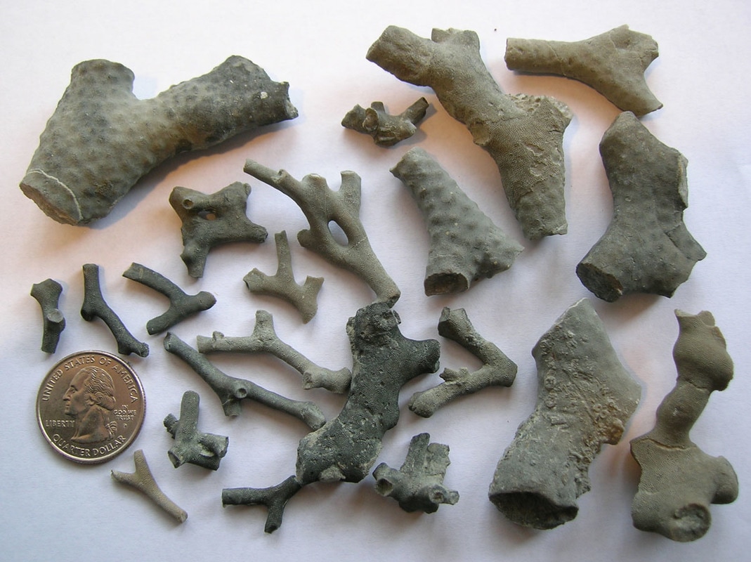 Brachiopods are marine animals that have a shell made of two valves, which usually differ in shape and size. Brachiopods are closely related to the bryozoans. Brachiopod comes from Latin and means "arm" + "foot" and bryzoan means "moss animal" 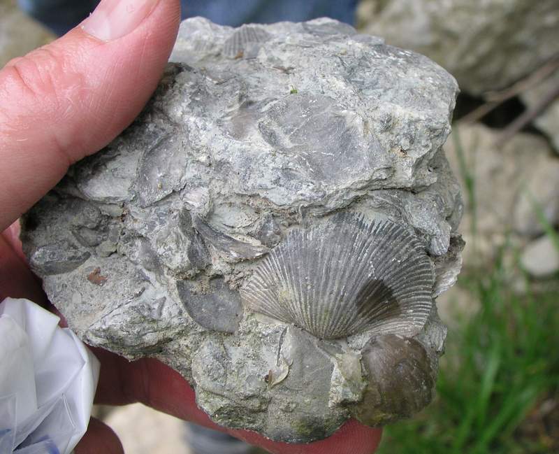 Brachiopods are solitary marine organisms that live between two valves or “shells.” They are very common in the Cincinnatian rocks of Ohio. They are externally different from the pelecypods (clams) in that the left and right halves of the brachiopod shells are usually mirror images of each other (see picture below). Internally, brachiopods are completely different from the pelecypods. Brachiopods feed with a special filtering organ called the lophophore which is located between the valves and attached to the brachial valve. The pedicle extends through a small opening or hole in the pedicle valve and is used as an anchoring device. The interior of the brachial valve is important in taxonomic differences between various species. 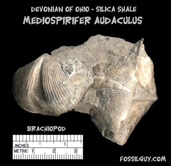 Crinoids 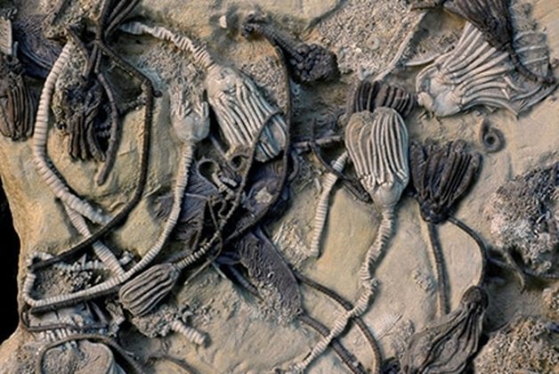 Crinoids are echinoderms that live on a long stalk, or column. Their crown is similar to an upside down starfish. Cross sections of the column usually have a tiny star within them. Columns and columnals are the most common parts found, although occasionally a crown or calyx can be found. It is rare to find the entire crinoid preserved. Crinoids are classified taxonomically by the characteristics of their crown, which makes identification of individual columns and columnals difficult unless the crown is attached. 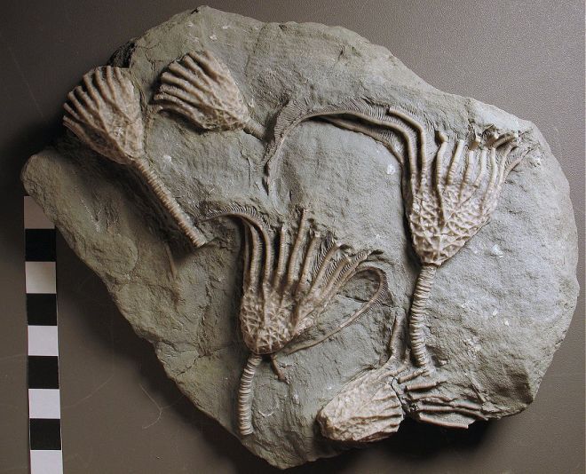 Crinoids are a sort of sea lily, an animal which attaches itself to the ocean floor, has a columnar stem and a flowery type of head. Crinoid comes from a Latin phrase that means "like a lily" 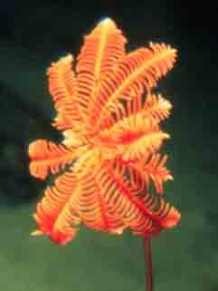 Gastropods 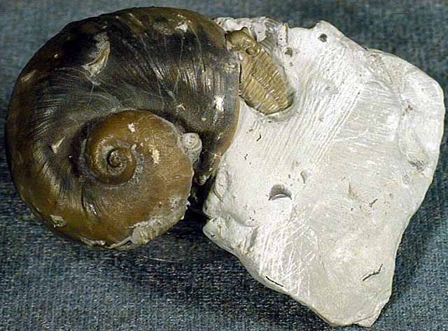 The gastropods, or snails, are extremely diverse inhabiting marine, fresh water and terrestrial environments. Their shell can coil in a conical (conispiral) or in in single plane (planispiral). 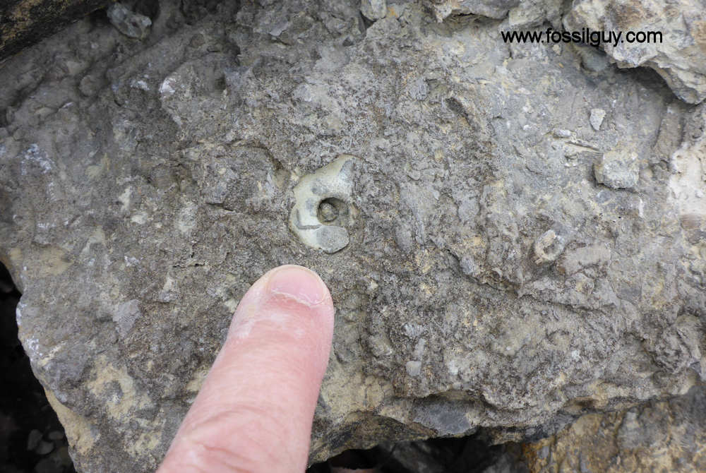 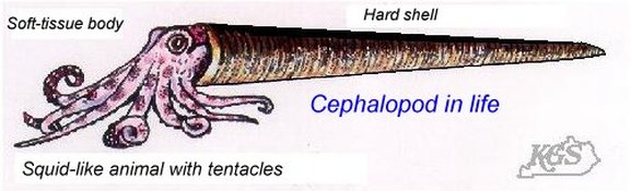 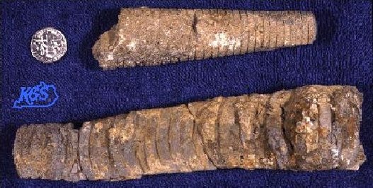 Cephalopods are members of the phylum Mollusca and include squid, octopi and the pearly nautilus. Cincinnatian cephalopods were straight shelled squids. The siphuncle connects the cameras (chambers) together. The squid could pass air to the chambers via the siphuncle to make it float higher in the water or sink as it swam.
 Horn Corals 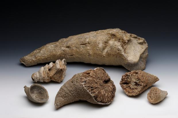 Phylum Cnidaria contains the corals, jellyfish, and anemones. Corals can be solitary or colonial. Corals have a rich fossil record because they excreted a hard calcium carbonate exoskeleton that preserves well. The Cincinnatian solitary corals are quite large, and are “horn” or “tooth” shaped. Individuals in the colonial corals are usually quite small, coralites being 1-3 mm in diameter. Additional References: Fossils of preserved remains can be:
Trace fossils are evidence left of past animal behavior. Some examples include:
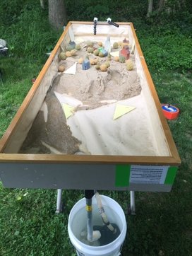
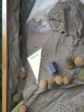
Index fossils (sometimes called guide fossils) are a special category of fossils that only occur in a specific location(s), therefore are often used to identify and define specific geologic periods (or faunal stages). www.virtualmuseumofgeology.com/fossils-gallery.html 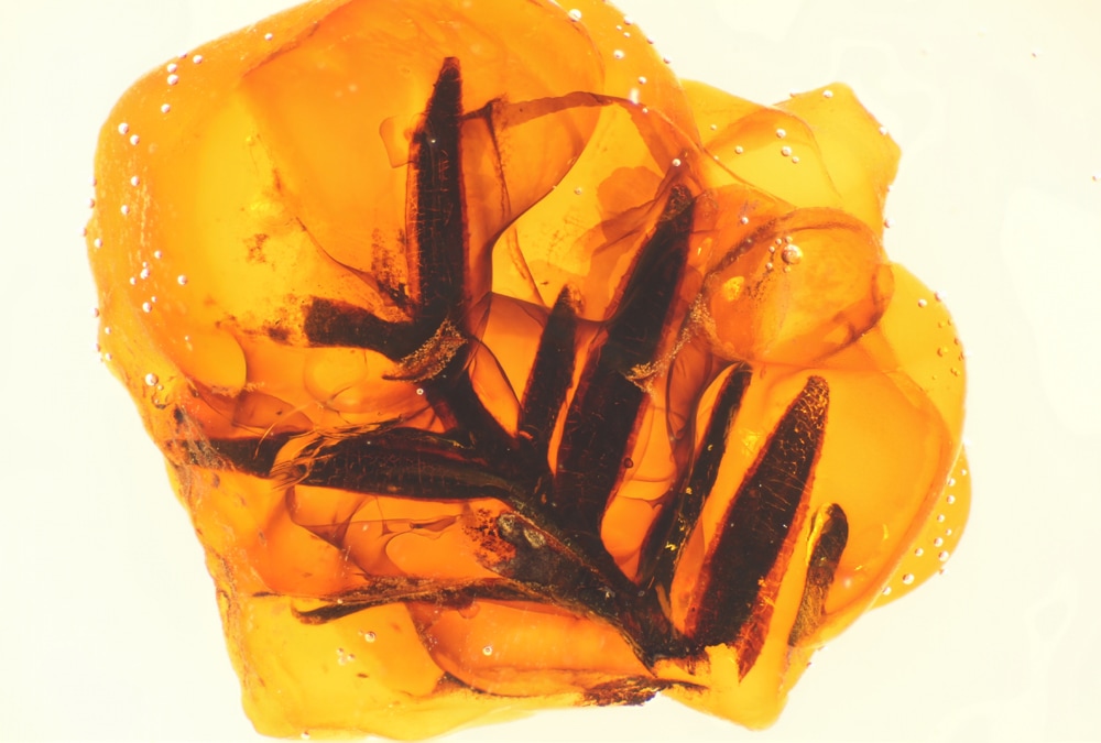 What is Amber? Amber is fossilized resin of a coniferous tree of early Tertiary. One of the differences between resin and sap is the latter's solubility in water since most of it is water from the xylem (water transporting system) of the tree. In this type of fossilization, the organism is entrapped in a biologically inert environment and preserved as a whole. Intact insects are often found in amber, though they may be altered slightly. Many physical and chemical agents of abiotic environment (the oxidative air and temperature) and biotic factors (bacteria and scavengers) accelerate the decomposition of a dead organism. Avoidance of these factors aids in preserving the organism and in the amber formation. The Process of Amber Formation: Organisms fall or drop into the resin when it first exudes out of the tree. Essential oils, called Oleoresins, compose most of the first deposited resin. This substance is volatile and is often lost through the years. Additional resin then falls on top and gives the organism its typical suspended appearance. The resin then hardens through a process called polymerization and becomes less vulnerable to destruction. This hardened resin, called copal, has a higher chance of being fossilized than pliable resin. As the copal ages, concentration of the essential oil decreases while the copal progressively oxidizes the resin and polymerization continues. The copal slowly turns into amber millions of years after the first entombment of the organism. The only way to differentiate between the two elements would be to put them through many physical and chemical tests such as UV light testing, burning, and various other tests. The most famous examples of amber have come from the Baltic Sea region (Germany, Poland, Lithuania, Denmark, the former Soviet Union, Great Britain, Estonia, Latvia, and Holland). Because of the presence of microscopic air bubbles, Baltic amber tends to appear cloudy or milky. The hue varies with quantity and quality of the bubbles. www.ucmp.berkeley.edu/paleo/fossils/amber.html Getting Into The Fossil Record - Teacher's Guide: www.ucmp.berkeley.edu/education/explorations/tours/fossil/  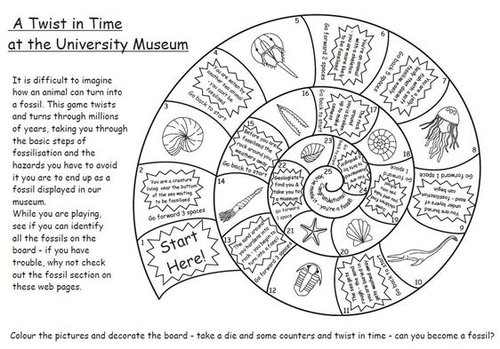 http://www.oum.ox.ac.uk/thezone/funstuff/games/pdfs/twist.pdf http://files.havefunteaching.com/free-worksheets/grade/third/science/fossils-worksheet-2.pdf 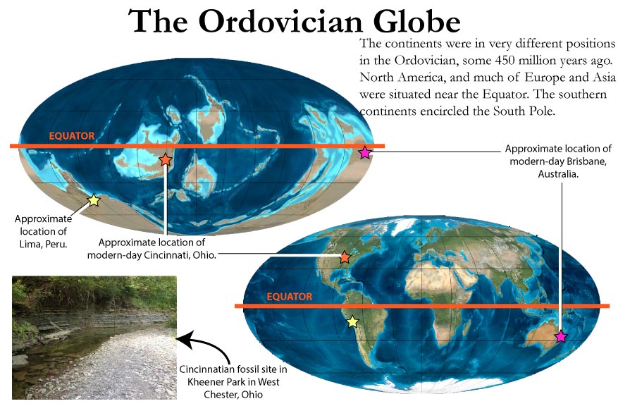 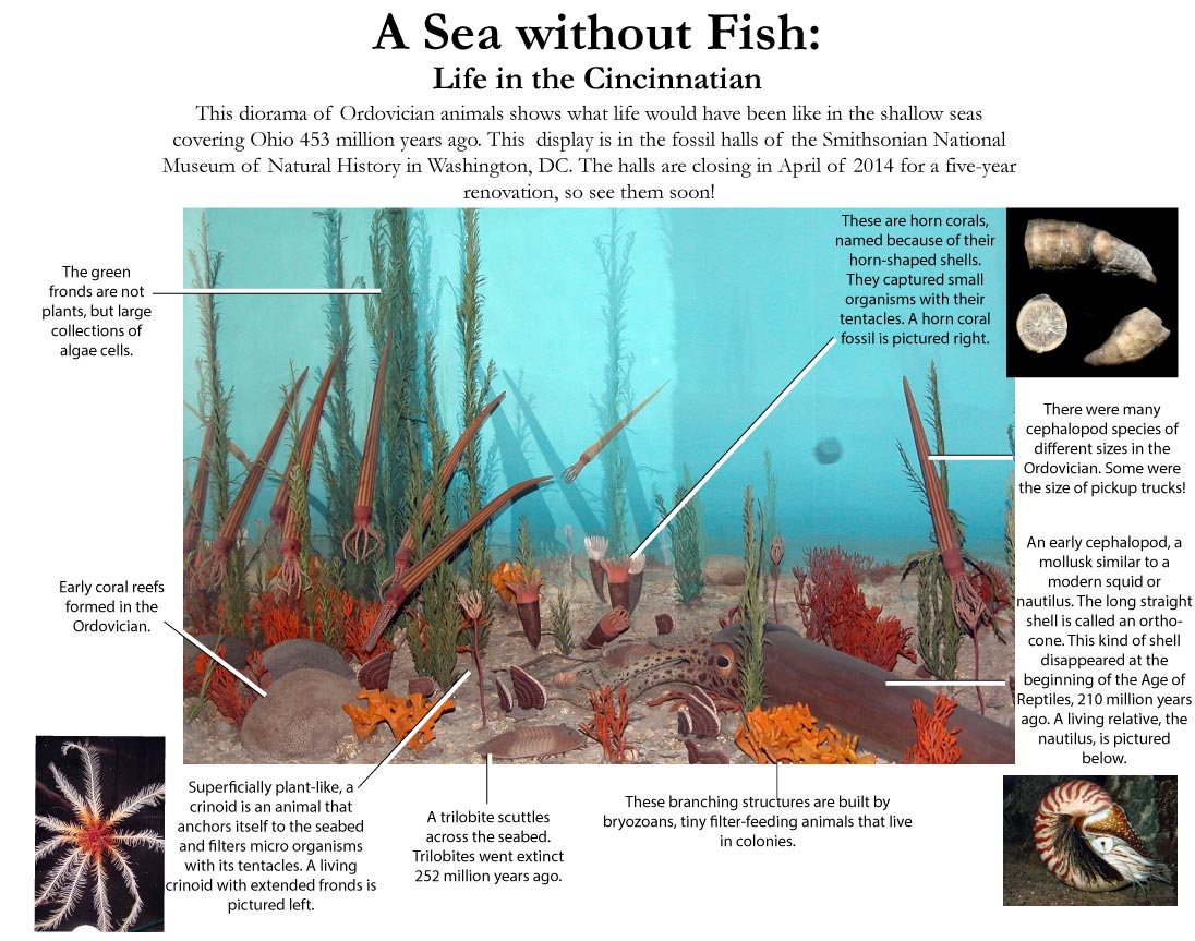 Working in classrooms across Warren County, we often hear 4th graders reciting rhymes, chants, or songs aimed at committing to memory the three processes that change our Earth's surface; Weathering breaks or changes it, Erosion takes or carries it, and Deposition drops or deposits it. Or in 8th grade classes, we witness students further investigating how combinations of constructive and destructive geological processes form Earth’s surface. Understanding these concepts falls in line with Ohio Learning Science Standards and also helps lay the foundation for students to observe and learn how and why our planet is shifting and changing. Then they can better study how human activity may play a role in the acceleration or deceleration of these changes, for we too are part of this system. One way Warren County SWCD assists in this learning experience is to bring in our interactive stream/geology table to the classroom for students to visually observe destructive erosion and constructive deposition in action. Students have the opportunity to make hypotheses about what they may see, and then participate in creating stream ecosystems and/or various land forms. Multiple scenarios can be developed to see how the addition or removal of elements changes the rate of weathering, erosion, and deposition on the model sand table.
By being able to visually watch formation of land forms, soil erode from river cut banks, and deltas form via deposition, students can connect the definition of these processes with real life effects. They also gain correct terminology and vocabulary to better discuss a river ecosystem and prepare them for future ecology studies.
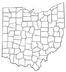
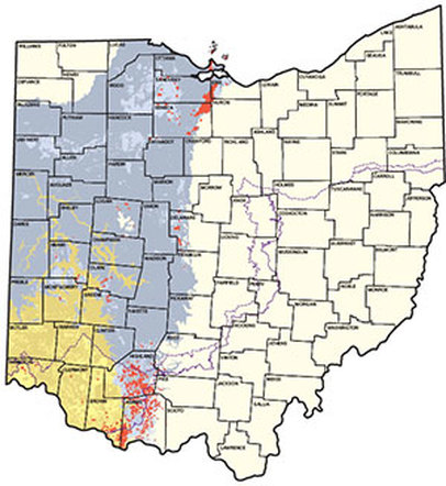
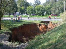
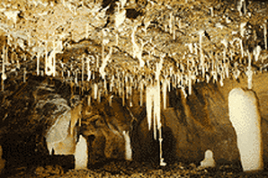
Weathering, erosion, and deposition are constantly occurring in our environment. Agents of change include water, wind, gravity, and ice. Studying earth formations through hands on demonstrations of different types of weathering and erosion, sets up students to delve into both the past and the future. Exploring topics like glacial evidence of mechanical weathering provides insight into how the Ohio landscape started to emerge. http://geology.teacherfriendlyguide.org/index.php/glaciers-mw/glaciers-landscapes-mw https://nsidc.org/cryosphere/glaciers/questions/land.html 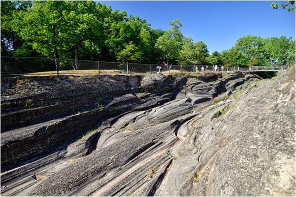 Kelly's Island, Sandusky, Ohio And how glacial melting from climate change may alter landscapes in the future... 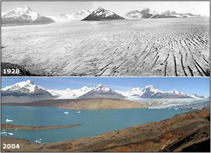 Muir's Inlet, Riggs Bay glacier River systems connect to topics of erosion which impacts human development and water quality issues. Sediment pollution in river systems affects ecological balances and drinking water. Streambank erosion in tributaries contribute to overall stream health. 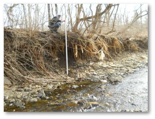 Turtle Creek, Lebanon Ohio Chemical weathering and erosion contribute to karst formations like sink holes and caves. These underground wonders can be explored with different activities and demonstrations. 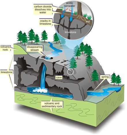 Ohio karst areas |
||||||||||||||||||||||||||||


 |  |
As education specialists, we are thrilled and excited to share knowledge with students and teachers that bring in real life examples pertaining to the rivers, formations, and ecosystems around their school district. Empowering students with ways they can help protect their local environment gives them an active role in conservation as well.
Some conservation tips to share:
Some conservation tips to share:
Recycle and Reuse
Place appropriate items in the recycling bin instead of the trash.
Choose rechargeable batteries, then recycle them when they die. You'd have to use hundreds of single-use batteries to equal the energy you'd get out of one rechargable battery. Be sure to recycle all batteries to keep harmful metals from entering the environment.
When you drink bottled water, reuse the bottle before recycling it. Or instead use a refillable water bottle rather than buying bottled water from the store.
Improve the Outdoors
Plant a deciduous (leafy) tree. Trees help clean the air we breathe. They produce oxygen and reduce carbon dioxide. Their roots help to stabilize soil and reduce erosion.
Participate in cleanup days at a beach or park. Use those outdoor trash cans! Never litter. Keep our waterways clean. When you visit a park or beach, be sure you deposit your trash in containers and volunteer at some state and national cleanups.
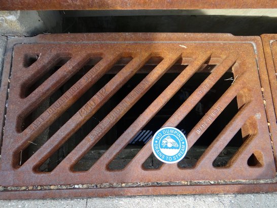
Safeguard Storm Drains
Don't litter. Trash tossed carelessly outside often washes into storm drains, which empty into rivers and streams that eventually flow to the oceans. Pollution is a growing problem for all the Earth's ocean and its wildlife.
Cut Down on Waste
Ban all drips. If you have a dripping faucet in the house, ask your parents to replace the washer inside it. If you stop a faucet from leaking one drop each second, you can save 2,700 gallons (10,220 liters) of water a year.
Don't pile your plate. "When's dinner?" you want to know. You're starving after a long day at school! Even so, restrain yourself and take only what you know you'll really be able to eat. Enough edible food to feed 49 million people ends up in landfills in the United States each year. When you do have food waste, compost it!
Spread the Word
Tell your friends! The more people who treat the Earth well, the safer all its inhabitants will be.
http://kids.nationalgeographic.com/explore/science/green-tips/#green-tips-tree.jpg
To learn more about the interactive stream/geology table and earth formations programs, or to schedule a classroom presentation, contact Marta or Melissa, Warren County SWCD's Education Specialists.
*Details also available about loan opportunities of the Stream / Geology Table to your classroom for teacher guided use.
*Details also available about loan opportunities of the Stream / Geology Table to your classroom for teacher guided use.
It’s not hard to recognize that here at the Warren County SWCD we work for the conservation of soil and water. Our story began in the 1930's with the Dust Bowl—"the largest man-made ecological disaster in the United States". During this time, the U.S. was losing millions of tons of soil a year due to severe drought and decades of extensive farming without proper farming practices.
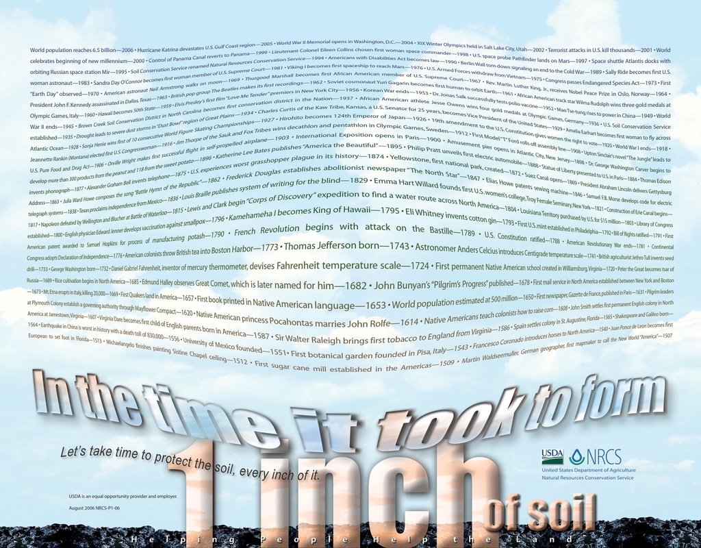
And soil is not an easy thing to replace! Did you know that it takes 500 years to form one inch of topsoil here in Ohio given the right conditions? The USDA/NRCS provides an excellent example of what 500 years looks like with this "Inch of Soil Poster". Factors that help build our soils, include: our parent material (bedrock), biological/living things, time, climate, and topography (relief).
https://nrcspad.sc.egov.usda.gov/distributioncenter/product.aspx?ProductID=192
Since that time, a number of other environmental issues continue to impact our way of life. Some of the greatest threats to our environment include a loss of biodiversity, human population growth, climate change, and pollution. We need more innovative problem solvers to help build a livable and sustainable world. Are you up for the challenge?
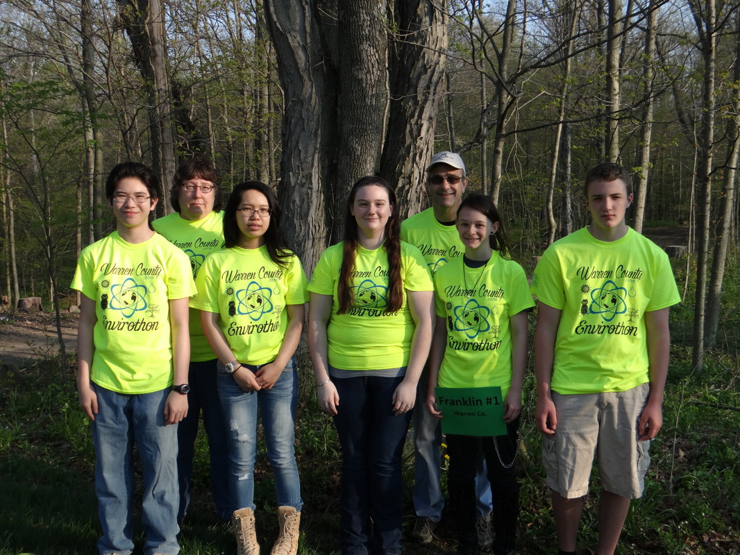
Warren County SWCD is here to help guide the next generation in thoughtful use of our natural resources and to help encourage careers in the environmental field. We do this by speaking at Warren County High Schools and by assisting schools in starting an Envirothon Team.
The Envirothon is an annual competition that tests students' knowledge of soils, forestry, wildlife, aquatic ecology and current environmental issues (CEI). The Envirothon is designed to stimulate, reinforce and enhance interest in the environment and natural resources among high school students. Our Area Envirothon is in the spring, but it’s not too early to start thinking about and forming your teams. Let us stop by your classroom and talk about starting a team at your school!
franklin high school envirothon team 2016