WARREN CO SWCD

6-8th

  • Home
    • About
    • Contact Us
    • Board Supervisors
    • Staff
    • NRCS
    • Employment Opportunities
    • Volunteer Opportunities
  • Upcoming Programs/Events
    • Ag Tour
    • Annual Meeting
    • Introduction to Kayaking
    • Lebanon Oktoberfest
    • Stream Clean Ups
    • Stream Encounters
    • Summer Contests
    • Urban Chat Series
    • Warren Water Striders
    • Women for the Land
    • Partner Events
  • Services
    • EQUIPMENT RENTAL
    • For Residents >
      • Drainage, Erosion & Pond Assistance
      • Soil Testing
      • Water Testing
      • Stormwater Basin Inspections
      • Maps & Historic Aerial Images
      • Backyard Conservation >
        • Ohio Native Plants
        • Pollinator Pathways
        • Rain Gardens
        • Rain Barrels
        • Composting
    • For Agriculture Producers >
      • Nutrient Management
      • Land Preservation
      • Cover Crops
      • GIS/Mapping
      • Caesar Creek Collaborative >
        • Meet the Collaborative
        • Our Work
    • 2024 H2Ohio Program
    • For Businesses >
      • Stormwater Basin Inspections
    • For Municipalities >
      • Illicit Discharge Detection Program
      • Operation Rain Garden Grants
  • PERMITS
    • Earth Disturbing in Warren County >
      • Earth Disturbing Permit Application
    • Floodplain Management >
      • Floodplain Determination Request Form
      • Flood Applications, Forms & Documents
  • Education
    • Programs >
      • Classroom Programs
      • Youth Programs
      • Community Outreach
    • Virtual Classroom
    • Urban Conservation Learning Lab
    • Dagmar the Dragonfly
    • Turtle Education Ambassador
    • Program Loan Portal
    • Scholarship Opportunities
    • HS Envirothon
    • Educator Workshops
  • Blogs
    • Conservation Connection
    • Development Digest
    • Education Connection

6th GRADE PROGRAM OFFERINGS

Soil Computer Lab 
  • Learning Objective: Students learn about mapping soils by using the Web Soil Survey to access geological and properties of soil types.
  • Activity: Students learn about soil types around them, reasons to study soil, and become scientists by mapping soil with the on-line Web Soil Survey.
  •   **Suggested that students have access to individual computers
Soil Testing
  • Learning Objective: Students use a dichotomous key to test soil.
  • Activity: Students become soil scientists by investigating and testing soil properties with a dichotomous key.
Soil Horizons
  • Learning Objective: Investigate the different soil horizons while comparing the mineral composition; realize our need for soil conservation.
  • Activity: Students focus on the layers found in soil and glue soil horizons on a card take home.
Rock Cycle Game
  • Learning Objective: Rocks form in different ways and have specific properties.
  • Activity: Students become minerals in the rock cycle and learn about everyday uses of rocks and minerals.


CLICK HERE TO VIEW Ohio Learning Standards-Science
​Grade 6
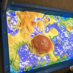
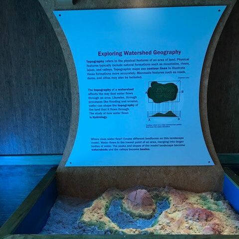
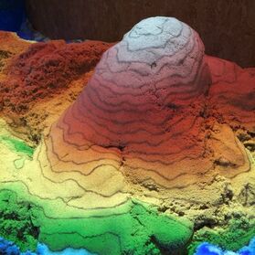
Augmented Reality Sandbox is available for topographic lessons for 7-8th grade classes!
Picture
Picture
Picture

7TH GRADE PROGRAM OFFERINGS
Macroinvertebrate Mayhem
  • ​​Learning Objective: Students will draw conclusions about how water quality influences diversity of populations of macroinvertebrates and will relate how population diversity provides insight into the health of an ecosystem
  • Activity: Students play a game of tag to simulate the effects of environmental stressors on macroinvertebrate populations.
Hydrological Cycle
  • Learning Objective: Students learn about the hydraulic cycle, pollution, and problems as pollution can move through the water cycle.
  • Activity: Students map their journey in the water cycle with beads and learn about water quality issues that are happening around Ohio.
Groundwater Model
  • Learning Objective: Water is collected, stored and removed in groundwater as well as pollution that can contaminate water.
  • Activity: A groundwater model is used to show how water flows through rock and what can contaminate the water.


​
Stream Field Trip
  • Learning Objective: Students learn about water quality by doing the following tests: pH, phosphate, nitrate, and macroinvertebrate collecting.
  • Activity: Students walk (or are bused) to a local stream to do water quality testing. 
CLICK HERE TO VIEW Ohio Learning Standards-Science
​ Grade 7
8TH GRADE PROGRAM OFFERINGS
Geology Table
  • Learning Objective: Students learn about different geological process and how a combination of constructive and destructive processes shape Earth's surface.
  • Activity: Students observe geological formations through an interactive sand table.
Bottleneck Genes
  • Learning Objective: Students learn about genetic diversity within a population.
  • Activity: Students do an activity calculating genetic diversity in a population and track changes in that population.
Topographic Maps
  • Learning Objective: Learn about geologic history, including processes like glacial movement that changed the Earth’s surface.
  • Activity: Students analyze a topographic map of their school’s location and conduct an activity with contour lines with our AR sandbox.
CLICK HERE TO VIEW Ohio Learning Standards-Science
​Grade 8
Picture

Contact:

PHONE: (513) 695 - 1337
EMAIL:   [email protected]
HOURS: Monday - Friday 7:30am - 4:00pm (except holidays)

Connect:

Warren County Soil & Water Conservation District Copyright © 2016
Warren SWCD Privacy Notice. Emails are serviced by Constant Contact.  Constant Contact's Privacy Notice.
  • Home
    • About
    • Contact Us
    • Board Supervisors
    • Staff
    • NRCS
    • Employment Opportunities
    • Volunteer Opportunities
  • Upcoming Programs/Events
    • Ag Tour
    • Annual Meeting
    • Introduction to Kayaking
    • Lebanon Oktoberfest
    • Stream Clean Ups
    • Stream Encounters
    • Summer Contests
    • Urban Chat Series
    • Warren Water Striders
    • Women for the Land
    • Partner Events
  • Services
    • EQUIPMENT RENTAL
    • For Residents >
      • Drainage, Erosion & Pond Assistance
      • Soil Testing
      • Water Testing
      • Stormwater Basin Inspections
      • Maps & Historic Aerial Images
      • Backyard Conservation >
        • Ohio Native Plants
        • Pollinator Pathways
        • Rain Gardens
        • Rain Barrels
        • Composting
    • For Agriculture Producers >
      • Nutrient Management
      • Land Preservation
      • Cover Crops
      • GIS/Mapping
      • Caesar Creek Collaborative >
        • Meet the Collaborative
        • Our Work
    • 2024 H2Ohio Program
    • For Businesses >
      • Stormwater Basin Inspections
    • For Municipalities >
      • Illicit Discharge Detection Program
      • Operation Rain Garden Grants
  • PERMITS
    • Earth Disturbing in Warren County >
      • Earth Disturbing Permit Application
    • Floodplain Management >
      • Floodplain Determination Request Form
      • Flood Applications, Forms & Documents
  • Education
    • Programs >
      • Classroom Programs
      • Youth Programs
      • Community Outreach
    • Virtual Classroom
    • Urban Conservation Learning Lab
    • Dagmar the Dragonfly
    • Turtle Education Ambassador
    • Program Loan Portal
    • Scholarship Opportunities
    • HS Envirothon
    • Educator Workshops
  • Blogs
    • Conservation Connection
    • Development Digest
    • Education Connection