|
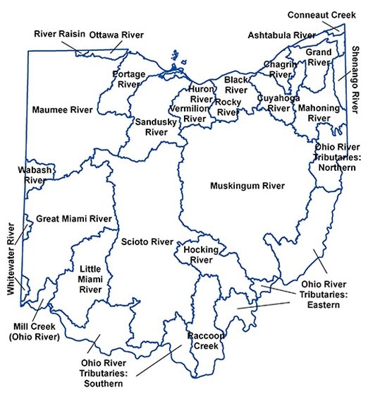
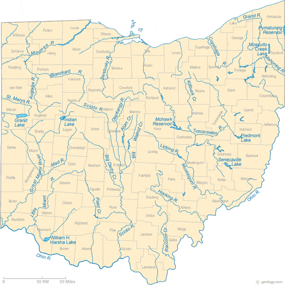
Communities across the globe are celebrating their rivers today, seeking to educate people about the threats facing our rivers, and learning about better water and energy solutions. Warren SWCD wants to take a moment to recognize the importance of our own local Ohio rivers! Ohio has 254 principal streams and large rivers in Ohio, comprising 5,679 linear stream miles (http://www.epa.ohio.gov/portals/35/tmdl/2012intreport/ir12sectionbfinal.pdf). The Ohio River forms the entire 451-mile southern boundary of Ohio, though the entire river stretches 981 miles from Pittsburgh, PA to Cairo, IL, and touches 6 states. 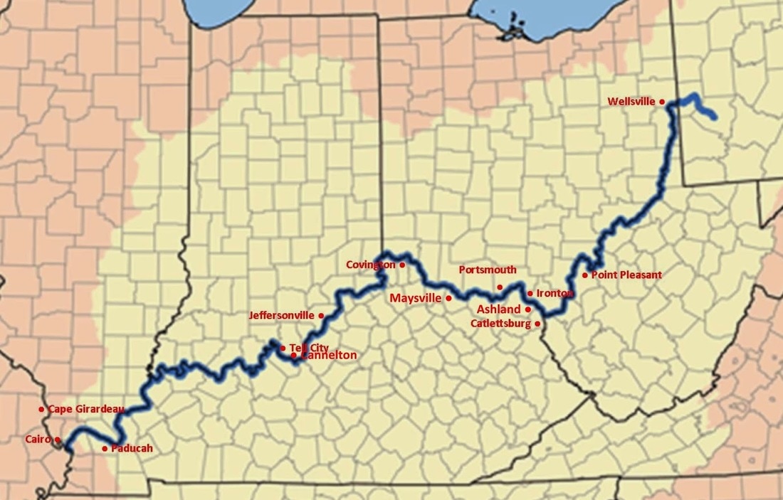 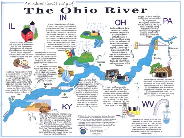 The Environmental Educational Council of Ohio and the Ohio EPA Of Ohio's rivers, 14 have been designated Scenic Rivers. Scenic rivers are classified according to the outstanding qualities a stream possesses. The Scenic Rivers Act provides three categories for river classification: wild, scenic and recreational. Stream length, adjacent forest cover, biological characteristics, water quality, present use, and natural conditions are all evaluated when considering designation. In 1968, Ohio pioneered the river preservation movement with the passage of the nation's first scenic rivers act. A state program was created to protect Ohio's remaining high quality streams for future generations. Scenic rivers retain most of their natural characteristics at a time when many rivers reflect the negative impacts of human activities. Scenic river designation is a cooperative venture among state and local government, citizen groups, and local communities within a watershed. The designation process depends ultimately upon support and protection authority of local governments and citizens. The ODNR studies the proposed river to determine whether it meets the scenic river criteria. All interested parties, including state and local officials, community groups and concerned citizens, meet to discuss the scenic rivers program and to encourage local support for the protection of the river as a natural resource. A legal notice of the intent to designate a river as wild, scenic or recreational is issued by the Director of Ohio DNR 60 days prior to the declaration to allow sufficient time for public comment. Following the public comment period, ODNR responds to public concerns and the Director may declare a river a component of the state scenic rivers system. On April 23, 1969, the Little Miami River which flows through Warren County earned the distinction of becoming Ohio's first designated State Scenic River. 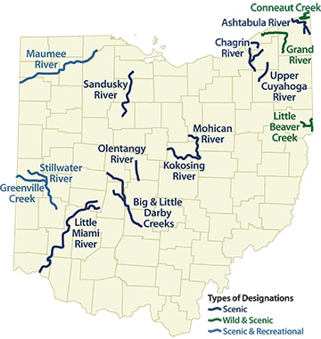
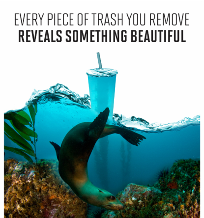
  watersheds of warren countyWhat is a watershed? A watershed is the area of land that drains into a lake or stream. Watersheds can be small - like the area that drains into the creek behind your house. Or, watersheds can be large - consider all the land, streams and rivers that drain into the Ohio River or Lake Erie (epa.ohio.gov) 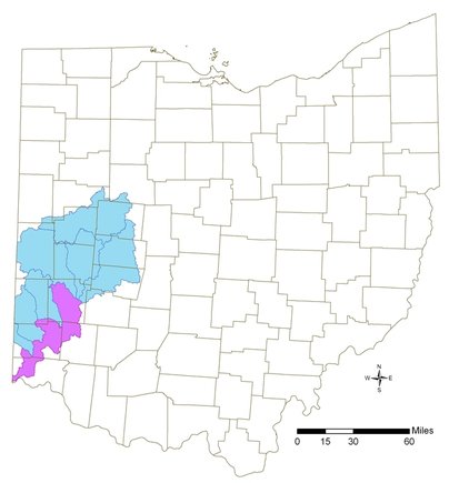 Great Miami River watershed (blue); Lower Great Miami River watershed (purple) 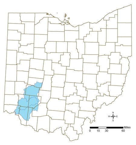 Little Miami River watershed Love your watershed!Want to help keep the Little Miami River watershed clean and protect surrounding habitat? There are simple steps you can take at home! 1. Use less water Every time you flush your toilet or leave the water running while brushing your teeth, it increases the load on your sewer system. Conserve water. 2. Keep your car repaired When oil leaks from our cars it is eventually sent down storm drains and ends up in the watershed. If your car has sprung an oil leak, get it fixed. Also, be careful while adding oil and make sure any used oil is properly recycled. 3. Use organic gardening techniques Go with natural fertilizers and stick to the directions. Make sure you do not overuse or apply on days when they are likely to be quickly washed away by rain. Just like automotive oil ends up in the watershed, so does a large amount of the fertilizers and pesticides you use in your garden. This causes rivers and lakes to get a huge dose of nitrogen which makes algae grow abnormally. The chemistry of our freshwater lakes and streams gets totally out of whack and fish kills are common, along with a host of other problems. 4. Compost and contain yard wasteToo much organic material clogs streams and when it breaks down, it can upset the water chemistry. Compost yard waste and make sure it’s in bins so it doesn’t wash away during a heavy rain. 5.Deal with household chemicals and medicines properly Check your local environmental health agency or solid waste department for drop-off locations or specially scheduled pickups for toxic household chemicals, like solvents, motor oil and paint. Do not flush unused medicines down the toilet. These are starting to turn up in local drinking water supplies. Find the best way to dispose of them locally. Also, use natural cleaning products around the house. 6. Go sustainable Frequent your local farmer’s market and find organic farmers. Doing business with them helps keep fertilizers and pesticides out of the environment and it also reduces the need to truck food over long distances, which reduces all the pollution associated with transportation. Also, Ohio is a free choice state for energy suppliers so you can buy electricity from sustainable sources and still be serviced by your local utility company. You can research 100% green energy suppliers such as CleanChoice Energy and Star Energy. It will reduce acid rain, which is one of our biggest problems. 7. Don’t litter While one may think we should not have to remind folks not to litter, still some people have not gotten the message. Go to any river or lake popular with fishermen and you will find plastic wrappers from lures and bait at the water’s edge. And, if you litter in your neighborhood, it will make its way to a storm drain and get into our streams, lakes and eventually into the ocean. Finally, why not take it a step further and volunteer for a river or lake cleanup day project? Check out http://www.lmriverkleeners.org/index.html for more information and volunteer opportunities! 
1 Comment
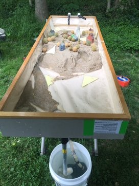
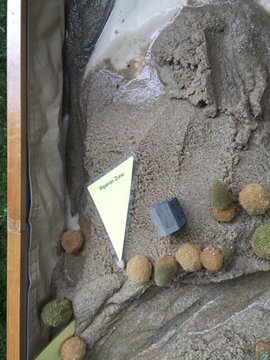
Working in classrooms across Warren County, we often hear 4th graders reciting rhymes, chants, or songs aimed at committing to memory the three processes that change our Earth's surface; Weathering breaks or changes it, Erosion takes or carries it, and Deposition drops or deposits it. Or in 8th grade classes, we witness students further investigating how combinations of constructive and destructive geological processes form Earth’s surface. Understanding these concepts falls in line with Ohio Learning Science Standards and also helps lay the foundation for students to observe and learn how and why our planet is shifting and changing. Then they can better study how human activity may play a role in the acceleration or deceleration of these changes, for we too are part of this system. One way Warren County SWCD assists in this learning experience is to bring in our interactive stream/geology table to the classroom for students to visually observe destructive erosion and constructive deposition in action. Students have the opportunity to make hypotheses about what they may see, and then participate in creating stream ecosystems and/or various land forms. Multiple scenarios can be developed to see how the addition or removal of elements changes the rate of weathering, erosion, and deposition on the model sand table.
By being able to visually watch formation of land forms, soil erode from river cut banks, and deltas form via deposition, students can connect the definition of these processes with real life effects. They also gain correct terminology and vocabulary to better discuss a river ecosystem and prepare them for future ecology studies.
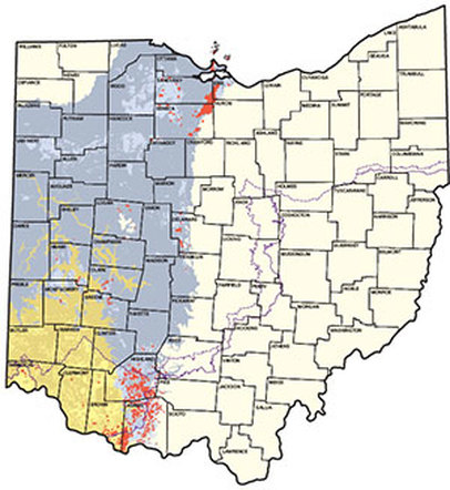
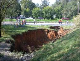
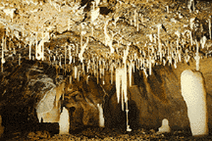
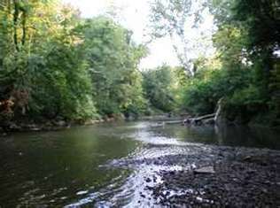
Weathering, erosion, and deposition are constantly occurring in our environment. Agents of change include water, wind, gravity, and ice. Studying earth formations through hands on demonstrations of different types of weathering and erosion, sets up students to delve into both the past and the future. Exploring topics like glacial evidence of mechanical weathering provides insight into how the Ohio landscape started to emerge. http://geology.teacherfriendlyguide.org/index.php/glaciers-mw/glaciers-landscapes-mw https://nsidc.org/cryosphere/glaciers/questions/land.html 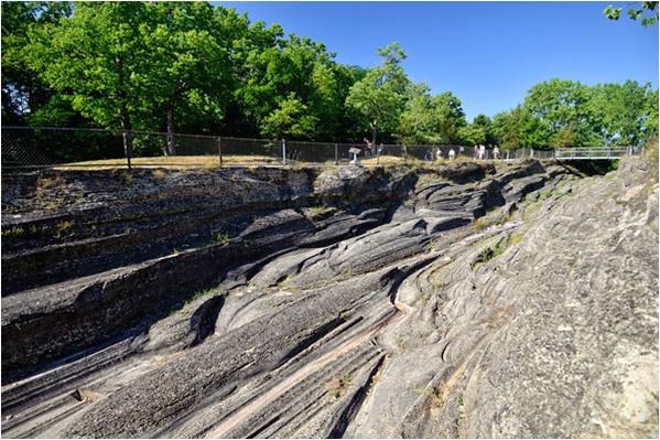 Kelly's Island, Sandusky, Ohio And how glacial melting from climate change may alter landscapes in the future... 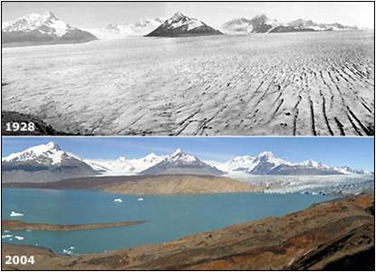 Muir's Inlet, Riggs Bay glacier River systems connect to topics of erosion which impacts human development and water quality issues. Sediment pollution in river systems affects ecological balances and drinking water. Streambank erosion in tributaries contribute to overall stream health. 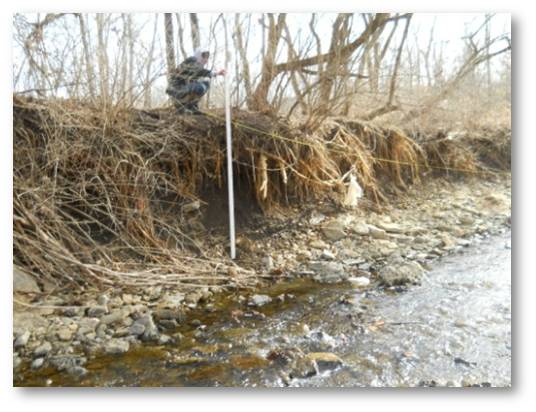 Turtle Creek, Lebanon Ohio Chemical weathering and erosion contribute to karst formations like sink holes and caves. These underground wonders can be explored with different activities and demonstrations. 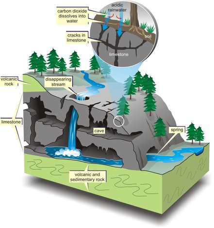 Ohio karst areas |
|||||||||||||||||
 |  |
As education specialists, we are thrilled and excited to share knowledge with students and teachers that bring in real life examples pertaining to the rivers, formations, and ecosystems around their school district. Empowering students with ways they can help protect their local environment gives them an active role in conservation as well.
Some conservation tips to share:
Some conservation tips to share:
Recycle and Reuse
Place appropriate items in the recycling bin instead of the trash.
Choose rechargeable batteries, then recycle them when they die. You'd have to use hundreds of single-use batteries to equal the energy you'd get out of one rechargable battery. Be sure to recycle all batteries to keep harmful metals from entering the environment.
When you drink bottled water, reuse the bottle before recycling it. Or instead use a refillable water bottle rather than buying bottled water from the store.
Improve the Outdoors
Plant a deciduous (leafy) tree. Trees help clean the air we breathe. They produce oxygen and reduce carbon dioxide. Their roots help to stabilize soil and reduce erosion.
Participate in cleanup days at a beach or park. Use those outdoor trash cans! Never litter. Keep our waterways clean. When you visit a park or beach, be sure you deposit your trash in containers and volunteer at some state and national cleanups.
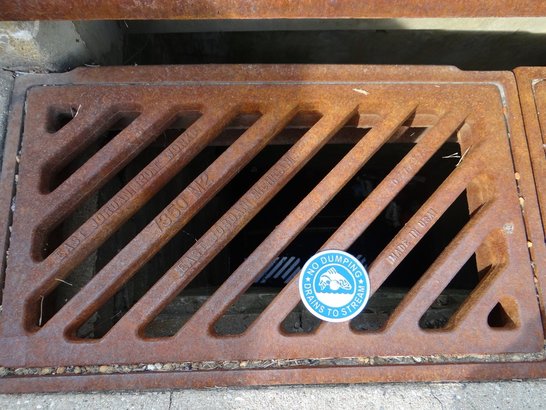
Safeguard Storm Drains
Don't litter. Trash tossed carelessly outside often washes into storm drains, which empty into rivers and streams that eventually flow to the oceans. Pollution is a growing problem for all the Earth's ocean and its wildlife.
Cut Down on Waste
Ban all drips. If you have a dripping faucet in the house, ask your parents to replace the washer inside it. If you stop a faucet from leaking one drop each second, you can save 2,700 gallons (10,220 liters) of water a year.
Don't pile your plate. "When's dinner?" you want to know. You're starving after a long day at school! Even so, restrain yourself and take only what you know you'll really be able to eat. Enough edible food to feed 49 million people ends up in landfills in the United States each year. When you do have food waste, compost it!
Spread the Word
Tell your friends! The more people who treat the Earth well, the safer all its inhabitants will be.
http://kids.nationalgeographic.com/explore/science/green-tips/#green-tips-tree.jpg
To learn more about the interactive stream/geology table and earth formations programs, or to schedule a classroom presentation, contact Marta or Melissa, Warren County SWCD's Education Specialists.
*Details also available about loan opportunities of the Stream / Geology Table to your classroom for teacher guided use.
*Details also available about loan opportunities of the Stream / Geology Table to your classroom for teacher guided use.
Far Out!
"Water is critical to sustaining life on Earth."
NASA Hydrological Science Research Portal:
https://neptune.gsfc.nasa.gov/hsb/
NASA Hydrological Science Research Portal:
https://neptune.gsfc.nasa.gov/hsb/
Study tracks “memory” of soil moisture
MIT News:
http://news.mit.edu/2017/smap-satellite-memory-soil-moisture-0116
MIT News:
http://news.mit.edu/2017/smap-satellite-memory-soil-moisture-0116
The Apple and The Earth:
http://www.iupui.edu/~ghw/lessons/materials/EarthAppleFarmlandNov02.pdf
Carefully peel an apple in quarters (4/4).
In comparison, three-fourths (3/4) of the apple represents the amount of water on Earth and one-fourth (1/4) represents Earth's total land surface.
Yet, one-eighth (1/8) of this slice of land is "Uninhabitable and Non-Arable Land" - approx. 1/8 of the Earth's surface is inhospitable to people and to crops. This includes areas such as polar regions, deserts, swamps, and high or rocky mountains.
The other one-eighth (1/8) represents one-half (1/2) of Earth's surface in which people live, but cannot necessarily grow food.
If this one-eighth (1/8) of the apple is sliced into 4 even cross-sections, consider that three out of thirty-two (3/32) slices represent land in which people can live but cannot grow food. "Some of it use to be arable, but isn't any longer because it has been developed or turned into cities, suburbs, highways, etc., so it can no longer be formed. Governments have earmarked other areas, such as parks, nature preserves and other public lands to remain undeveloped forever".
This leaves 1/32 remaining, which we will call our "most valuable part" - our "topsoil". Topsoil is our dark nutrient-rich soil that holds moisture and feeds us by feeding our crops. "Currently, 90% of U.S. croplands lose soil above the 'sustainable rate'."
Some Facts About Farmland:
"Erosion by wind and water is the most serious cause of soil loss and degradation. Although it is a natural process, erosion is accelerated greatly by things like construction, deforestation, and unsustainable practices in farming and animal grazing.
In the U.S., soil is now eroding at 17 times the rate at which it forms (via 2014). The soil erosion rate is estimated to be double in Asia, Africa, and South America. In order to feed the nearly 80 million humans added to the population annually, 12 million acres of new land must be put into production.
More than 25 million acres of productive arable land are severely degraded and abandoned worldwide every year—that’s an area the size of the states of Ohio, Indiana, Illinois, Michigan, Wisconsin, and Minnesota put together."
How can we preserve farmland?
By not building on arable land: Land covered up by buildings, highways, and other forms of development can't be used for growing crops. In the U.S., nearly 2.2 million acres of land are converted to urban and other uses each year. About 25% of that land is former cropland.
By eating lower on the food chain: While over a billion people suffer from malnutrition or starvation, meat production requires a disproportionate amount of grain input. Producing a pound of beef in a feed lot requires seven pounds of grain, a pound of pork requires four, and a pound of poultry requires two pounds of grain. The land that is used to produce grain for consumption by animals is unavailable for growing grain for human consumption.
By reducing pollution: Pollution impairs the ability of the land and the seas to provide food that's both sufficient in quantity and free of contaminants.
By stabilizing human population growth: Food supply is an excellent example of the relationship between any resource and the size and consumption patterns of the population that depends on it. Simply put, the more people there are to feed, the less food there is to go around.
Source: http://www.iupui.edu/~ghw/lessons/materials/EarthAppleFarmlandNov02.pdf
ODA: Preserving Farmland
http://www.agri.ohio.gov/divs/FarmLand/
http://www.agri.ohio.gov/divs/FarmLand/
Explore Climate Change Topics and Discover What Actions Humans Can Take
Author: Marta Farrell, Education Specialist
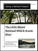
Thankfully, organizations and many individuals work wisely to protect and preserve our streams. The Little Miami River is one of America's National Wild and Scenic Rivers. "The Little Miami River Kleeners' and Little Miami Watershed Network's purpose is to enhance the quality of life along the Little Miami River by promoting the protection of, stimulating the public interest in, and encouraging the preservation of the Little Miami River."
Saving a National Treasure: The Little Miami Conservancy was founded in 1967 as Little Miami, Inc. The Little Miami River has been embraced by citizens and local leaders as a valuable natural resource for quiet outdoor recreation, wildlife, drinking water, scenic beauty and much more!
On April 23, 1969, the Little Miami River earned the distinction of becoming
Ohio's first designated State Scenic River.
Ohio's first designated State Scenic River.
Little Miami State and National Scenic River: Rivers and streams in the Ohio Scenic Rivers program are monitored regularly to ensure that the water habitat quality remains high. The Stream Quality Monitoring (SQM) program is coordinated by regional employees, but most of the monitoring is done by volunteers.
Volunteers are needed!
Become a SQM Volunteer Monitor:
Become a SQM Volunteer Monitor:
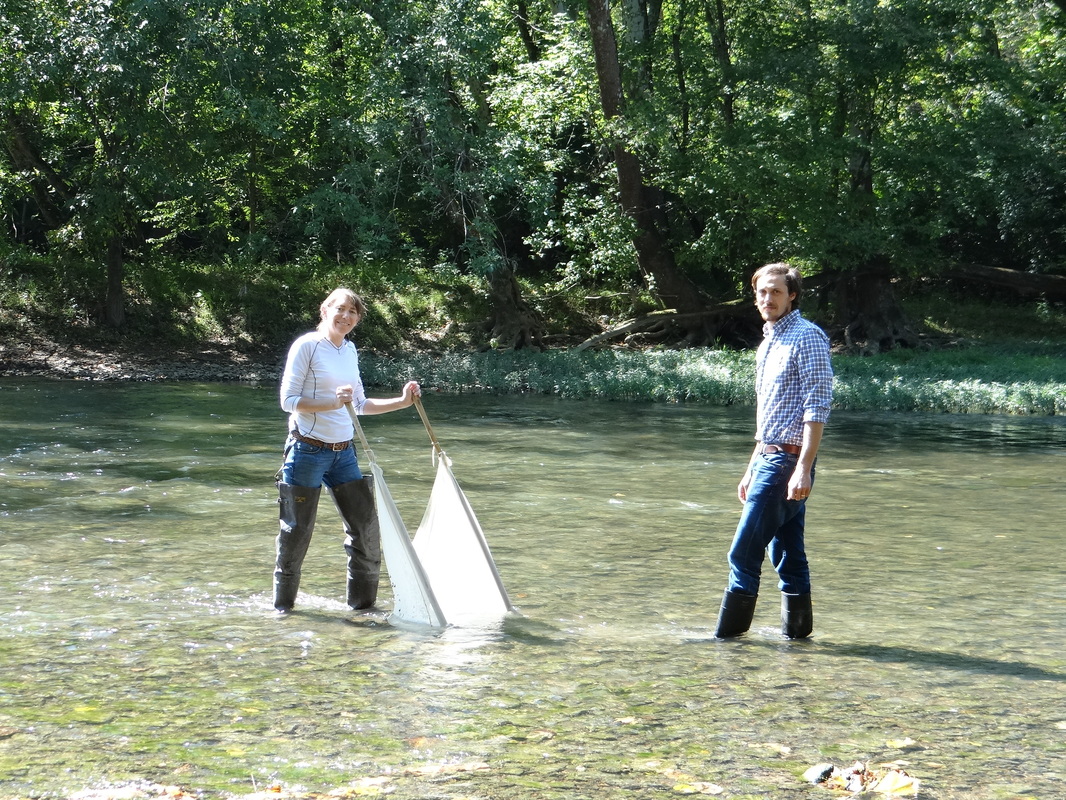
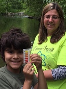
Warren SWCD participates in the ODNR Stream Quality Program. Our testing site is at river mile 44 on the Little Miami River. If you would like to learn more about Stream Water Quality Monitoring or volunteer with Warren SWCD doing Stream Water Quality Monitoring, please e-mail our staff coordinator, Molly Conley, or click on the black box below for additional information: molly.conley@co.warren.oh.us
6/2/2016
How Clean are our Streams... Mason students visit muddy creek to discover first hand
Read Now 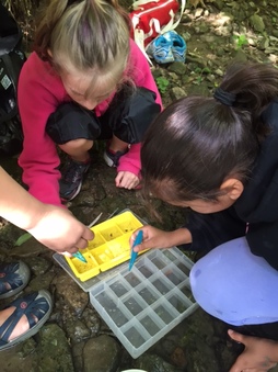 |
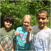 |
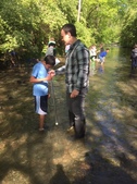
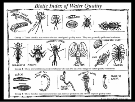
Thank you Mrs. Quill for planning a stream field trip and collaborating with WCSWCD to test the waters at Muddy Creek in Mason, Ohio! The students found Benthic Macroinvertebrates in all three Taxa's.
5/23/2016
Thank you local artists, Attendees and sponsors of the Rain Barrel Benefit Auction
Read Now 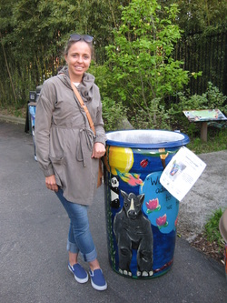 | 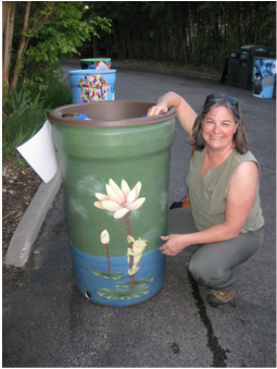 |
Picture highlights from the Rain Barrel Benefit Auction held during the Party for the Planet Event at the Cincinnati Zoo and Botanical Gardens on April 28, 2016.
Also see: SaveLocalWaters.org - The Regional Storm Water Collaborative
Also see: SaveLocalWaters.org - The Regional Storm Water Collaborative
Where is Earth's Water: http://water.usgs.gov/edu/earthwherewater.html
Where is Earth's Water: USGS Website